You are here: Home > Network List > TA - USArray Transportable Network (new EarthScope stations) Stations List
> Station G65A Princeton, ME, USA > Earthquake Result Viewer
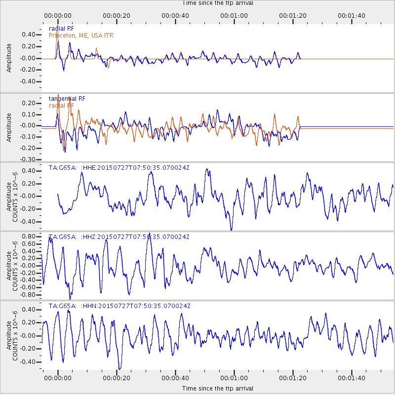
G65A Princeton, ME, USA - Earthquake Result Viewer
*The percent match for this event was below the threshold and hence no stack was calculated.
| Earthquake location: |
Fox Islands, Aleutian Islands |
| Earthquake latitude/longitude: |
52.3/-169.1 |
| Earthquake time(UTC): |
2015/07/27 (208) 07:40:49 GMT |
| Earthquake Depth: |
33 km |
| Earthquake Magnitude: |
5.5 mb |
| Earthquake Catalog/Contributor: |
ISC/ISC |
|
| Network: |
TA USArray Transportable Network (new EarthScope stations) |
| Station: |
G65A Princeton, ME, USA |
| Lat/Lon: |
45.20 N/67.56 W |
| Elevation: |
78 m |
|
| Distance: |
61.9 deg |
| Az: |
51.75 deg |
| Baz: |
316.977 deg |
| Ray Param: |
$rayparam |
*The percent match for this event was below the threshold and hence was not used in the summary stack. |
|
| Radial Match: |
69.385635 % |
| Radial Bump: |
400 |
| Transverse Match: |
72.58917 % |
| Transverse Bump: |
400 |
| SOD ConfigId: |
7422571 |
| Insert Time: |
2019-04-20 00:42:31.694 +0000 |
| GWidth: |
2.5 |
| Max Bumps: |
400 |
| Tol: |
0.001 |
|
Signal To Noise
| Channel | StoN | STA | LTA |
| TA:G65A: :HHZ:20150727T07:50:35.070024Z | 1.8991143 | 4.4423578E-7 | 2.3391736E-7 |
| TA:G65A: :HHN:20150727T07:50:35.070024Z | 2.3848689 | 2.8593527E-7 | 1.198956E-7 |
| TA:G65A: :HHE:20150727T07:50:35.070024Z | 1.4065621 | 2.3270248E-7 | 1.654406E-7 |
| Arrivals |
| Ps | |
| PpPs | |
| PsPs/PpSs | |


