You are here: Home > Network List > TA - USArray Transportable Network (new EarthScope stations) Stations List
> Station I59A Olmsteadville, NY, USA > Earthquake Result Viewer
I59A Olmsteadville, NY, USA - Earthquake Result Viewer
| Earthquake location: |
Fox Islands, Aleutian Islands |
| Earthquake latitude/longitude: |
52.3/-169.1 |
| Earthquake time(UTC): |
2015/07/27 (208) 07:40:49 GMT |
| Earthquake Depth: |
33 km |
| Earthquake Magnitude: |
5.5 mb |
| Earthquake Catalog/Contributor: |
ISC/ISC |
|
| Network: |
TA USArray Transportable Network (new EarthScope stations) |
| Station: |
I59A Olmsteadville, NY, USA |
| Lat/Lon: |
43.80 N/73.87 W |
| Elevation: |
390 m |
|
| Distance: |
59.8 deg |
| Az: |
56.584 deg |
| Baz: |
314.924 deg |
| Ray Param: |
0.061920147 |
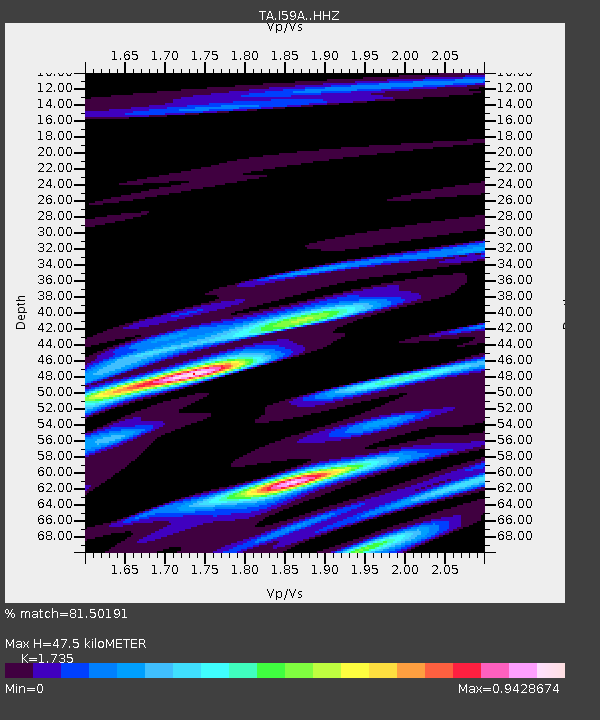
| Estimated Moho Depth: |
47.5 km |
| Estimated Crust Vp/Vs: |
1.74 |
| Assumed Crust Vp: |
6.419 km/s |
| Estimated Crust Vs: |
3.7 km/s |
| Estimated Crust Poisson's Ratio: |
0.25 |
|
| Radial Match: |
81.50191 % |
| Radial Bump: |
400 |
| Transverse Match: |
73.96189 % |
| Transverse Bump: |
400 |
| SOD ConfigId: |
7422571 |
| Insert Time: |
2019-04-20 00:42:36.782 +0000 |
| GWidth: |
2.5 |
| Max Bumps: |
400 |
| Tol: |
0.001 |
|
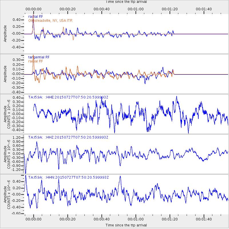
Signal To Noise
| Channel | StoN | STA | LTA |
| TA:I59A: :HHZ:20150727T07:50:20.599993Z | 1.6449475 | 3.718471E-7 | 2.2605407E-7 |
| TA:I59A: :HHN:20150727T07:50:20.599993Z | 2.1454399 | 2.2950351E-7 | 1.0697271E-7 |
| TA:I59A: :HHE:20150727T07:50:20.599993Z | 1.2525194 | 1.2376184E-7 | 9.881032E-8 |
| Arrivals |
| Ps | 5.7 SECOND |
| PpPs | 19 SECOND |
| PsPs/PpSs | 25 SECOND |


