You are here: Home > Network List > TA - USArray Transportable Network (new EarthScope stations) Stations List
> Station M53A WI Miller and Sons, Farmdale, OH, USA > Earthquake Result Viewer
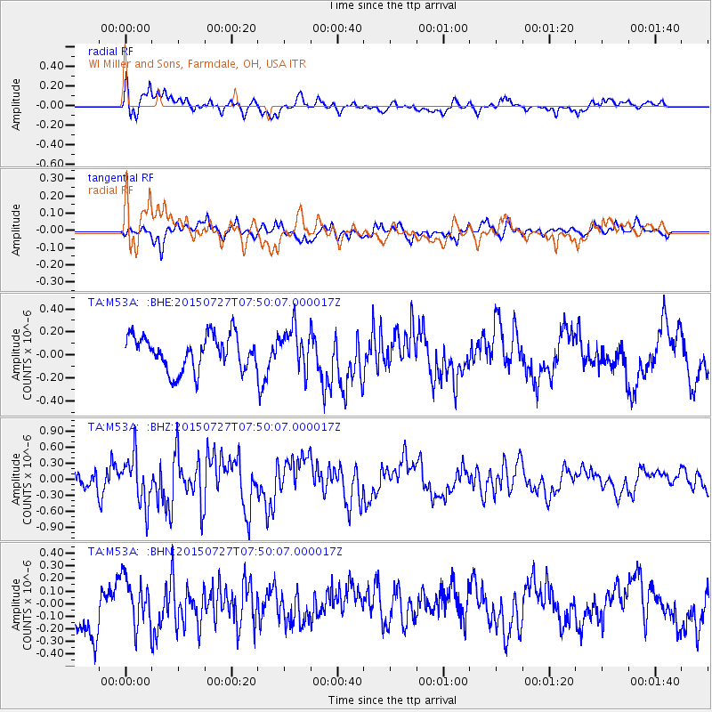
M53A WI Miller and Sons, Farmdale, OH, USA - Earthquake Result Viewer
*The percent match for this event was below the threshold and hence no stack was calculated.
| Earthquake location: |
Fox Islands, Aleutian Islands |
| Earthquake latitude/longitude: |
52.3/-169.1 |
| Earthquake time(UTC): |
2015/07/27 (208) 07:40:49 GMT |
| Earthquake Depth: |
33 km |
| Earthquake Magnitude: |
5.5 mb |
| Earthquake Catalog/Contributor: |
ISC/ISC |
|
| Network: |
TA USArray Transportable Network (new EarthScope stations) |
| Station: |
M53A WI Miller and Sons, Farmdale, OH, USA |
| Lat/Lon: |
41.44 N/80.68 W |
| Elevation: |
334 m |
|
| Distance: |
57.8 deg |
| Az: |
62.647 deg |
| Baz: |
313.477 deg |
| Ray Param: |
$rayparam |
*The percent match for this event was below the threshold and hence was not used in the summary stack. |
|
| Radial Match: |
76.5325 % |
| Radial Bump: |
400 |
| Transverse Match: |
48.3118 % |
| Transverse Bump: |
400 |
| SOD ConfigId: |
7422571 |
| Insert Time: |
2019-04-20 00:42:45.384 +0000 |
| GWidth: |
2.5 |
| Max Bumps: |
400 |
| Tol: |
0.001 |
|
Signal To Noise
| Channel | StoN | STA | LTA |
| TA:M53A: :BHZ:20150727T07:50:07.000017Z | 2.9208682 | 4.5795778E-7 | 1.5678823E-7 |
| TA:M53A: :BHN:20150727T07:50:07.000017Z | 1.1587943 | 1.8377003E-7 | 1.5858727E-7 |
| TA:M53A: :BHE:20150727T07:50:07.000017Z | 1.214142 | 1.8183815E-7 | 1.497668E-7 |
| Arrivals |
| Ps | |
| PpPs | |
| PsPs/PpSs | |


