You are here: Home > Network List > TA - USArray Transportable Network (new EarthScope stations) Stations List
> Station O48A Farmland, IN, USA > Earthquake Result Viewer
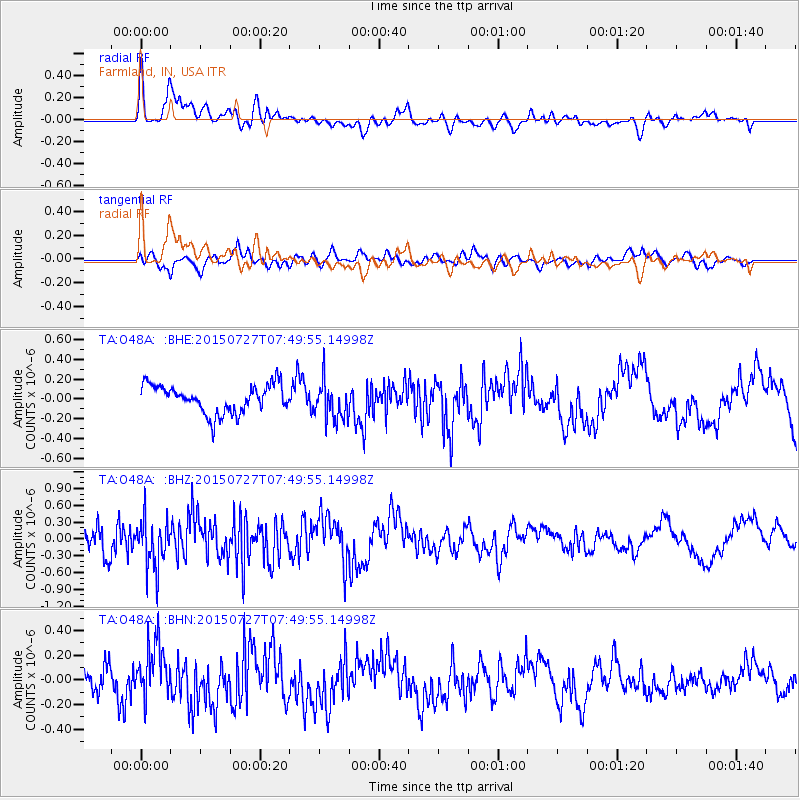
O48A Farmland, IN, USA - Earthquake Result Viewer
*The percent match for this event was below the threshold and hence no stack was calculated.
| Earthquake location: |
Fox Islands, Aleutian Islands |
| Earthquake latitude/longitude: |
52.3/-169.1 |
| Earthquake time(UTC): |
2015/07/27 (208) 07:40:49 GMT |
| Earthquake Depth: |
33 km |
| Earthquake Magnitude: |
5.5 mb |
| Earthquake Catalog/Contributor: |
ISC/ISC |
|
| Network: |
TA USArray Transportable Network (new EarthScope stations) |
| Station: |
O48A Farmland, IN, USA |
| Lat/Lon: |
40.26 N/85.16 W |
| Elevation: |
300 m |
|
| Distance: |
56.1 deg |
| Az: |
66.443 deg |
| Baz: |
312.628 deg |
| Ray Param: |
$rayparam |
*The percent match for this event was below the threshold and hence was not used in the summary stack. |
|
| Radial Match: |
75.71989 % |
| Radial Bump: |
400 |
| Transverse Match: |
73.17963 % |
| Transverse Bump: |
400 |
| SOD ConfigId: |
7422571 |
| Insert Time: |
2019-04-20 00:42:49.432 +0000 |
| GWidth: |
2.5 |
| Max Bumps: |
400 |
| Tol: |
0.001 |
|
Signal To Noise
| Channel | StoN | STA | LTA |
| TA:O48A: :BHZ:20150727T07:49:55.14998Z | 2.2321901 | 4.2606783E-7 | 1.9087435E-7 |
| TA:O48A: :BHN:20150727T07:49:55.14998Z | 2.3702881 | 2.2562305E-7 | 9.518803E-8 |
| TA:O48A: :BHE:20150727T07:49:55.14998Z | 1.3415282 | 1.9064979E-7 | 1.4211389E-7 |
| Arrivals |
| Ps | |
| PpPs | |
| PsPs/PpSs | |


