You are here: Home > Network List > 7A - Mid-Atlantic Geophysical Integrative Collaboration Stations List
> Station KENT Kenton, Ohio USA > Earthquake Result Viewer
KENT Kenton, Ohio USA - Earthquake Result Viewer
| Earthquake location: |
Fox Islands, Aleutian Islands |
| Earthquake latitude/longitude: |
52.5/-169.7 |
| Earthquake time(UTC): |
2015/07/27 (208) 07:41:02 GMT |
| Earthquake Depth: |
16 km |
| Earthquake Magnitude: |
5.6 MB |
| Earthquake Catalog/Contributor: |
NEIC PDE/NEIC COMCAT |
|
| Network: |
7A Mid-Atlantic Geophysical Integrative Collaboration |
| Station: |
KENT Kenton, Ohio USA |
| Lat/Lon: |
40.63 N/83.64 W |
| Elevation: |
296 m |
|
| Distance: |
57.0 deg |
| Az: |
64.887 deg |
| Baz: |
313.283 deg |
| Ray Param: |
0.06376073 |
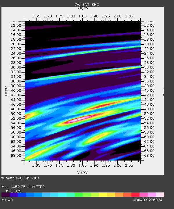
| Estimated Moho Depth: |
52.25 km |
| Estimated Crust Vp/Vs: |
1.83 |
| Assumed Crust Vp: |
6.498 km/s |
| Estimated Crust Vs: |
3.56 km/s |
| Estimated Crust Poisson's Ratio: |
0.29 |
|
| Radial Match: |
80.455864 % |
| Radial Bump: |
400 |
| Transverse Match: |
53.55592 % |
| Transverse Bump: |
400 |
| SOD ConfigId: |
7422571 |
| Insert Time: |
2019-04-20 00:45:44.808 +0000 |
| GWidth: |
2.5 |
| Max Bumps: |
400 |
| Tol: |
0.001 |
|

Signal To Noise
| Channel | StoN | STA | LTA |
| 7A:KENT: :BHZ:20150727T07:50:16.040022Z | 0.6686837 | 2.3959169E-7 | 3.5830345E-7 |
| 7A:KENT: :BHN:20150727T07:50:16.040022Z | 2.0358903 | 2.8614426E-7 | 1.4054994E-7 |
| 7A:KENT: :BHE:20150727T07:50:16.040022Z | 1.0223886 | 1.7458481E-7 | 1.707617E-7 |
| Arrivals |
| Ps | 7.0 SECOND |
| PpPs | 22 SECOND |
| PsPs/PpSs | 29 SECOND |


