You are here: Home > Network List > TA - USArray Transportable Network (new EarthScope stations) Stations List
> Station J60A Lant Hill Farm, Argyle, NY, USA > Earthquake Result Viewer
J60A Lant Hill Farm, Argyle, NY, USA - Earthquake Result Viewer
| Earthquake location: |
Fox Islands, Aleutian Islands |
| Earthquake latitude/longitude: |
52.5/-169.7 |
| Earthquake time(UTC): |
2015/07/27 (208) 07:41:02 GMT |
| Earthquake Depth: |
16 km |
| Earthquake Magnitude: |
5.6 MB |
| Earthquake Catalog/Contributor: |
NEIC PDE/NEIC COMCAT |
|
| Network: |
TA USArray Transportable Network (new EarthScope stations) |
| Station: |
J60A Lant Hill Farm, Argyle, NY, USA |
| Lat/Lon: |
43.24 N/73.42 W |
| Elevation: |
265 m |
|
| Distance: |
60.6 deg |
| Az: |
56.47 deg |
| Baz: |
315.728 deg |
| Ray Param: |
0.06140508 |
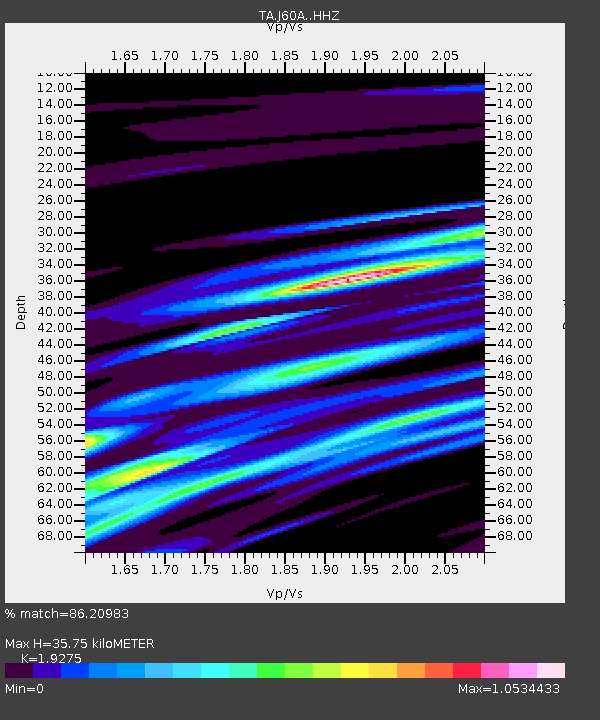
| Estimated Moho Depth: |
35.75 km |
| Estimated Crust Vp/Vs: |
1.93 |
| Assumed Crust Vp: |
6.419 km/s |
| Estimated Crust Vs: |
3.33 km/s |
| Estimated Crust Poisson's Ratio: |
0.32 |
|
| Radial Match: |
86.20983 % |
| Radial Bump: |
345 |
| Transverse Match: |
59.503887 % |
| Transverse Bump: |
400 |
| SOD ConfigId: |
7422571 |
| Insert Time: |
2019-04-20 00:50:52.482 +0000 |
| GWidth: |
2.5 |
| Max Bumps: |
400 |
| Tol: |
0.001 |
|

Signal To Noise
| Channel | StoN | STA | LTA |
| TA:J60A: :HHZ:20150727T07:50:41.10002Z | 0.97432816 | 4.7617405E-7 | 4.887204E-7 |
| TA:J60A: :HHN:20150727T07:50:41.10002Z | 1.6248132 | 3.0553917E-7 | 1.8804572E-7 |
| TA:J60A: :HHE:20150727T07:50:41.10002Z | 1.5495619 | 3.029239E-7 | 1.9549003E-7 |
| Arrivals |
| Ps | 5.4 SECOND |
| PpPs | 16 SECOND |
| PsPs/PpSs | 21 SECOND |


