You are here: Home > Network List > TA - USArray Transportable Network (new EarthScope stations) Stations List
> Station M53A WI Miller and Sons, Farmdale, OH, USA > Earthquake Result Viewer
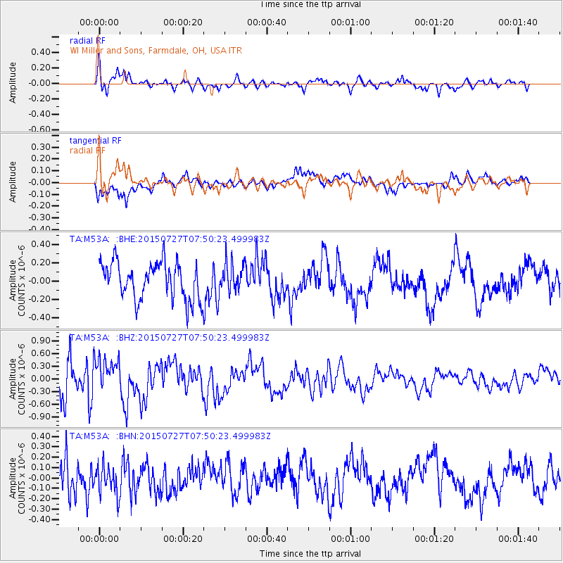
M53A WI Miller and Sons, Farmdale, OH, USA - Earthquake Result Viewer
*The percent match for this event was below the threshold and hence no stack was calculated.
| Earthquake location: |
Fox Islands, Aleutian Islands |
| Earthquake latitude/longitude: |
52.5/-169.7 |
| Earthquake time(UTC): |
2015/07/27 (208) 07:41:02 GMT |
| Earthquake Depth: |
16 km |
| Earthquake Magnitude: |
5.6 MB |
| Earthquake Catalog/Contributor: |
NEIC PDE/NEIC COMCAT |
|
| Network: |
TA USArray Transportable Network (new EarthScope stations) |
| Station: |
M53A WI Miller and Sons, Farmdale, OH, USA |
| Lat/Lon: |
41.44 N/80.68 W |
| Elevation: |
334 m |
|
| Distance: |
58.1 deg |
| Az: |
62.36 deg |
| Baz: |
313.863 deg |
| Ray Param: |
$rayparam |
*The percent match for this event was below the threshold and hence was not used in the summary stack. |
|
| Radial Match: |
76.36032 % |
| Radial Bump: |
400 |
| Transverse Match: |
54.381523 % |
| Transverse Bump: |
400 |
| SOD ConfigId: |
7422571 |
| Insert Time: |
2019-04-20 00:50:57.441 +0000 |
| GWidth: |
2.5 |
| Max Bumps: |
400 |
| Tol: |
0.001 |
|
Signal To Noise
| Channel | StoN | STA | LTA |
| TA:M53A: :BHZ:20150727T07:50:23.499983Z | 1.1108042 | 3.9995993E-7 | 3.600634E-7 |
| TA:M53A: :BHN:20150727T07:50:23.499983Z | 0.76872635 | 1.520388E-7 | 1.9778012E-7 |
| TA:M53A: :BHE:20150727T07:50:23.499983Z | 0.78776777 | 1.6117728E-7 | 2.046E-7 |
| Arrivals |
| Ps | |
| PpPs | |
| PsPs/PpSs | |


