You are here: Home > Network List > TA - USArray Transportable Network (new EarthScope stations) Stations List
> Station O03E Paynes Creek, CA, USA > Earthquake Result Viewer
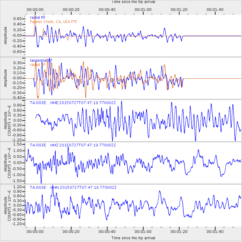
O03E Paynes Creek, CA, USA - Earthquake Result Viewer
*The percent match for this event was below the threshold and hence no stack was calculated.
| Earthquake location: |
Fox Islands, Aleutian Islands |
| Earthquake latitude/longitude: |
52.5/-169.7 |
| Earthquake time(UTC): |
2015/07/27 (208) 07:41:02 GMT |
| Earthquake Depth: |
16 km |
| Earthquake Magnitude: |
5.6 MB |
| Earthquake Catalog/Contributor: |
NEIC PDE/NEIC COMCAT |
|
| Network: |
TA USArray Transportable Network (new EarthScope stations) |
| Station: |
O03E Paynes Creek, CA, USA |
| Lat/Lon: |
40.29 N/121.80 W |
| Elevation: |
967 m |
|
| Distance: |
34.6 deg |
| Az: |
91.124 deg |
| Baz: |
306.881 deg |
| Ray Param: |
$rayparam |
*The percent match for this event was below the threshold and hence was not used in the summary stack. |
|
| Radial Match: |
70.59407 % |
| Radial Bump: |
400 |
| Transverse Match: |
50.587055 % |
| Transverse Bump: |
400 |
| SOD ConfigId: |
7422571 |
| Insert Time: |
2019-04-20 00:51:00.169 +0000 |
| GWidth: |
2.5 |
| Max Bumps: |
400 |
| Tol: |
0.001 |
|
Signal To Noise
| Channel | StoN | STA | LTA |
| TA:O03E: :HHZ:20150727T07:47:19.770002Z | 1.6408833 | 5.612473E-7 | 3.4203975E-7 |
| TA:O03E: :HHN:20150727T07:47:19.770002Z | 1.3376229 | 4.1783923E-7 | 3.1237448E-7 |
| TA:O03E: :HHE:20150727T07:47:19.770002Z | 1.5318854 | 4.4391632E-7 | 2.8978428E-7 |
| Arrivals |
| Ps | |
| PpPs | |
| PsPs/PpSs | |


