You are here: Home > Network List > UW - Pacific Northwest Regional Seismic Network Stations List
> Station MRBL Marblemount, WA, USA > Earthquake Result Viewer
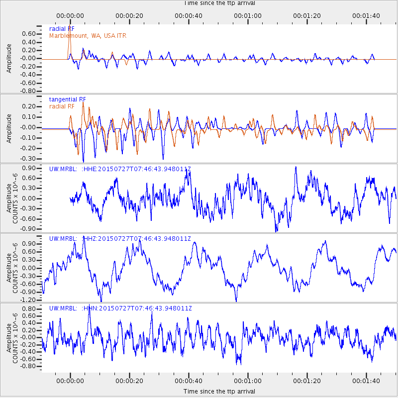
MRBL Marblemount, WA, USA - Earthquake Result Viewer
*The percent match for this event was below the threshold and hence no stack was calculated.
| Earthquake location: |
Fox Islands, Aleutian Islands |
| Earthquake latitude/longitude: |
52.5/-169.7 |
| Earthquake time(UTC): |
2015/07/27 (208) 07:41:02 GMT |
| Earthquake Depth: |
16 km |
| Earthquake Magnitude: |
5.6 MB |
| Earthquake Catalog/Contributor: |
NEIC PDE/NEIC COMCAT |
|
| Network: |
UW Pacific Northwest Regional Seismic Network |
| Station: |
MRBL Marblemount, WA, USA |
| Lat/Lon: |
48.52 N/121.48 W |
| Elevation: |
75 m |
|
| Distance: |
30.5 deg |
| Az: |
77.837 deg |
| Baz: |
295.881 deg |
| Ray Param: |
$rayparam |
*The percent match for this event was below the threshold and hence was not used in the summary stack. |
|
| Radial Match: |
69.92873 % |
| Radial Bump: |
400 |
| Transverse Match: |
72.58591 % |
| Transverse Bump: |
400 |
| SOD ConfigId: |
7422571 |
| Insert Time: |
2019-04-20 00:51:46.579 +0000 |
| GWidth: |
2.5 |
| Max Bumps: |
400 |
| Tol: |
0.001 |
|
Signal To Noise
| Channel | StoN | STA | LTA |
| UW:MRBL: :HHZ:20150727T07:46:43.948011Z | 1.8542027 | 7.190238E-7 | 3.8778055E-7 |
| UW:MRBL: :HHN:20150727T07:46:43.948011Z | 1.0890887 | 1.9950166E-7 | 1.8318221E-7 |
| UW:MRBL: :HHE:20150727T07:46:43.948011Z | 0.7007443 | 1.9250614E-7 | 2.7471668E-7 |
| Arrivals |
| Ps | |
| PpPs | |
| PsPs/PpSs | |


