You are here: Home > Network List > US - United States National Seismic Network Stations List
> Station EGMT Eagleton, Montana, USA > Earthquake Result Viewer
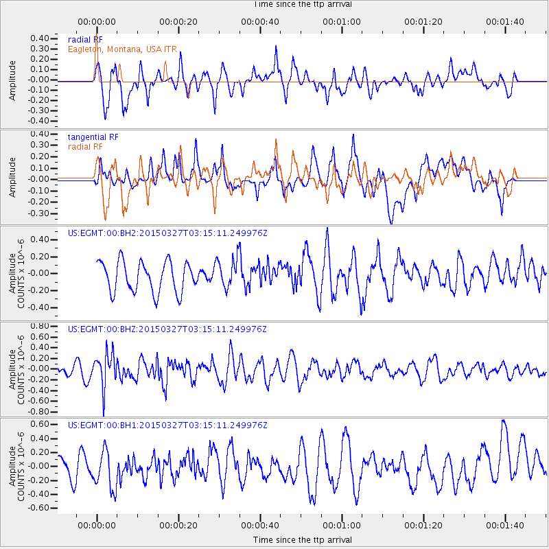
EGMT Eagleton, Montana, USA - Earthquake Result Viewer
*The percent match for this event was below the threshold and hence no stack was calculated.
| Earthquake location: |
Off East Coast Of Honshu, Japan |
| Earthquake latitude/longitude: |
36.3/143.1 |
| Earthquake time(UTC): |
2015/03/27 (086) 03:04:05 GMT |
| Earthquake Depth: |
0.2 km |
| Earthquake Magnitude: |
5.5 MWP |
| Earthquake Catalog/Contributor: |
NEIC PDE/NEIC COMCAT |
|
| Network: |
US United States National Seismic Network |
| Station: |
EGMT Eagleton, Montana, USA |
| Lat/Lon: |
48.02 N/109.75 W |
| Elevation: |
1055 m |
|
| Distance: |
73.9 deg |
| Az: |
41.894 deg |
| Baz: |
306.543 deg |
| Ray Param: |
$rayparam |
*The percent match for this event was below the threshold and hence was not used in the summary stack. |
|
| Radial Match: |
66.22168 % |
| Radial Bump: |
400 |
| Transverse Match: |
55.82802 % |
| Transverse Bump: |
400 |
| SOD ConfigId: |
872571 |
| Insert Time: |
2015-04-10 03:17:09.602 +0000 |
| GWidth: |
2.5 |
| Max Bumps: |
400 |
| Tol: |
0.001 |
|
Signal To Noise
| Channel | StoN | STA | LTA |
| US:EGMT:00:BHZ:20150327T03:15:11.249976Z | 2.9256368 | 3.078175E-7 | 1.0521384E-7 |
| US:EGMT:00:BH1:20150327T03:15:11.249976Z | 1.8689959 | 2.8959033E-7 | 1.5494433E-7 |
| US:EGMT:00:BH2:20150327T03:15:11.249976Z | 1.0108047 | 1.8010434E-7 | 1.7817918E-7 |
| Arrivals |
| Ps | |
| PpPs | |
| PsPs/PpSs | |


