You are here: Home > Network List > CI - Caltech Regional Seismic Network Stations List
> Station GLA Glamis, California, USA > Earthquake Result Viewer
GLA Glamis, California, USA - Earthquake Result Viewer
| Earthquake location: |
Costa Rica |
| Earthquake latitude/longitude: |
8.8/-84.0 |
| Earthquake time(UTC): |
2002/06/16 (167) 02:46:14 GMT |
| Earthquake Depth: |
35 km |
| Earthquake Magnitude: |
5.4 MB, 6.2 MS, 6.4 MW, 6.4 MW |
| Earthquake Catalog/Contributor: |
WHDF/NEIC |
|
| Network: |
CI Caltech Regional Seismic Network |
| Station: |
GLA Glamis, California, USA |
| Lat/Lon: |
33.05 N/114.83 W |
| Elevation: |
627 m |
|
| Distance: |
37.3 deg |
| Az: |
314.777 deg |
| Baz: |
123.339 deg |
| Ray Param: |
0.07612716 |
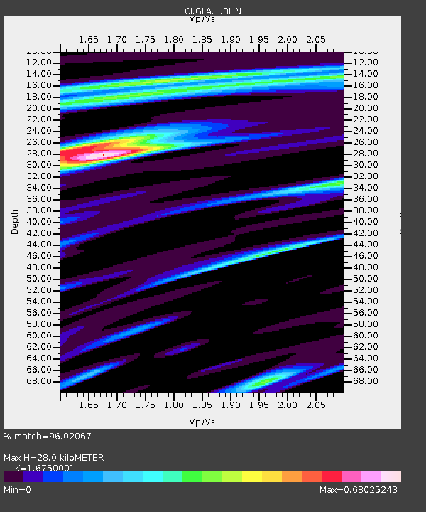
| Estimated Moho Depth: |
28.0 km |
| Estimated Crust Vp/Vs: |
1.68 |
| Assumed Crust Vp: |
6.155 km/s |
| Estimated Crust Vs: |
3.674 km/s |
| Estimated Crust Poisson's Ratio: |
0.22 |
|
| Radial Match: |
96.02067 % |
| Radial Bump: |
301 |
| Transverse Match: |
78.84647 % |
| Transverse Bump: |
400 |
| SOD ConfigId: |
3787 |
| Insert Time: |
2010-02-25 21:44:26.123 +0000 |
| GWidth: |
2.5 |
| Max Bumps: |
400 |
| Tol: |
0.001 |
|

Signal To Noise
| Channel | StoN | STA | LTA |
| CI:GLA: :BHN:20020616T02:52:52.635011Z | 2.6268787 | 1.923563E-7 | 7.322618E-8 |
| CI:GLA: :BHE:20020616T02:52:52.635011Z | 2.2455103 | 1.7498293E-7 | 7.7925684E-8 |
| CI:GLA: :BHZ:20020616T02:52:52.635011Z | 4.040386 | 4.4729694E-7 | 1.1070649E-7 |
| Arrivals |
| Ps | 3.3 SECOND |
| PpPs | 11 SECOND |
| PsPs/PpSs | 15 SECOND |


