You are here: Home > Network List > AK - Alaska Regional Network Stations List
> Station CUT Chulitna, AK, USA > Earthquake Result Viewer
CUT Chulitna, AK, USA - Earthquake Result Viewer
| Earthquake location: |
Irian Jaya, Indonesia |
| Earthquake latitude/longitude: |
-2.7/138.5 |
| Earthquake time(UTC): |
2015/07/27 (208) 21:41:22 GMT |
| Earthquake Depth: |
53 km |
| Earthquake Magnitude: |
7.0 MWP, 7.0 MI |
| Earthquake Catalog/Contributor: |
NEIC PDE/NEIC COMCAT |
|
| Network: |
AK Alaska Regional Network |
| Station: |
CUT Chulitna, AK, USA |
| Lat/Lon: |
62.41 N/150.26 W |
| Elevation: |
574 m |
|
| Distance: |
83.8 deg |
| Az: |
26.332 deg |
| Baz: |
252.089 deg |
| Ray Param: |
0.045844078 |
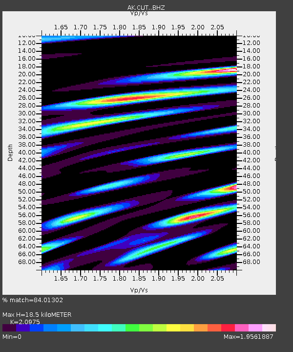
| Estimated Moho Depth: |
18.5 km |
| Estimated Crust Vp/Vs: |
2.10 |
| Assumed Crust Vp: |
6.438 km/s |
| Estimated Crust Vs: |
3.069 km/s |
| Estimated Crust Poisson's Ratio: |
0.35 |
|
| Radial Match: |
84.01302 % |
| Radial Bump: |
400 |
| Transverse Match: |
82.02331 % |
| Transverse Bump: |
400 |
| SOD ConfigId: |
7422571 |
| Insert Time: |
2019-04-20 01:01:31.452 +0000 |
| GWidth: |
2.5 |
| Max Bumps: |
400 |
| Tol: |
0.001 |
|

Signal To Noise
| Channel | StoN | STA | LTA |
| AK:CUT: :BHZ:20150727T21:53:13.78002Z | 11.342256 | 2.9393589E-6 | 2.591512E-7 |
| AK:CUT: :BHN:20150727T21:53:13.78002Z | 3.6798816 | 8.857387E-7 | 2.406976E-7 |
| AK:CUT: :BHE:20150727T21:53:13.78002Z | 3.154007 | 9.215713E-7 | 2.9219063E-7 |
| Arrivals |
| Ps | 3.2 SECOND |
| PpPs | 8.7 SECOND |
| PsPs/PpSs | 12 SECOND |


