You are here: Home > Network List > AK - Alaska Regional Network Stations List
> Station FALS False Pass > Earthquake Result Viewer
FALS False Pass - Earthquake Result Viewer
| Earthquake location: |
Irian Jaya, Indonesia |
| Earthquake latitude/longitude: |
-2.7/138.5 |
| Earthquake time(UTC): |
2015/07/27 (208) 21:41:22 GMT |
| Earthquake Depth: |
53 km |
| Earthquake Magnitude: |
7.0 MWP, 7.0 MI |
| Earthquake Catalog/Contributor: |
NEIC PDE/NEIC COMCAT |
|
| Network: |
AK Alaska Regional Network |
| Station: |
FALS False Pass |
| Lat/Lon: |
54.86 N/163.42 W |
| Elevation: |
46 m |
|
| Distance: |
74.5 deg |
| Az: |
30.625 deg |
| Baz: |
241.652 deg |
| Ray Param: |
0.05218426 |
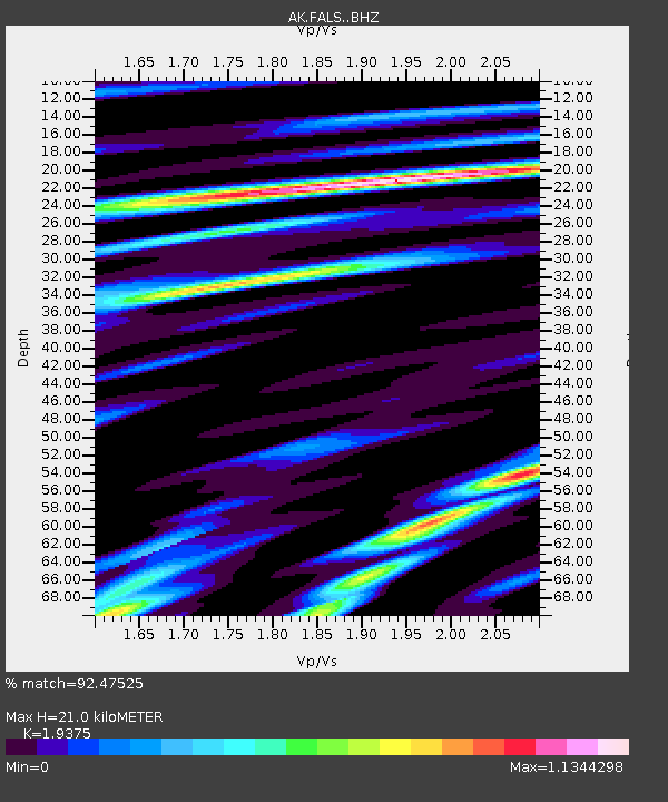
| Estimated Moho Depth: |
21.0 km |
| Estimated Crust Vp/Vs: |
1.94 |
| Assumed Crust Vp: |
5.989 km/s |
| Estimated Crust Vs: |
3.091 km/s |
| Estimated Crust Poisson's Ratio: |
0.32 |
|
| Radial Match: |
92.47525 % |
| Radial Bump: |
400 |
| Transverse Match: |
85.965096 % |
| Transverse Bump: |
400 |
| SOD ConfigId: |
7422571 |
| Insert Time: |
2019-04-20 01:01:35.407 +0000 |
| GWidth: |
2.5 |
| Max Bumps: |
400 |
| Tol: |
0.001 |
|

Signal To Noise
| Channel | StoN | STA | LTA |
| AK:FALS: :BHZ:20150727T21:52:23.247976Z | 7.2037416 | 3.275675E-6 | 4.5471856E-7 |
| AK:FALS: :BHN:20150727T21:52:23.247976Z | 3.1108034 | 1.2625746E-6 | 4.058677E-7 |
| AK:FALS: :BHE:20150727T21:52:23.247976Z | 2.2880898 | 1.7405058E-6 | 7.606808E-7 |
| Arrivals |
| Ps | 3.4 SECOND |
| PpPs | 10 SECOND |
| PsPs/PpSs | 13 SECOND |


