You are here: Home > Network List > AK - Alaska Regional Network Stations List
> Station TABL Table Mountain, AK, USA > Earthquake Result Viewer
TABL Table Mountain, AK, USA - Earthquake Result Viewer
| Earthquake location: |
Irian Jaya, Indonesia |
| Earthquake latitude/longitude: |
-2.7/138.5 |
| Earthquake time(UTC): |
2015/07/27 (208) 21:41:22 GMT |
| Earthquake Depth: |
53 km |
| Earthquake Magnitude: |
7.0 MWP, 7.0 MI |
| Earthquake Catalog/Contributor: |
NEIC PDE/NEIC COMCAT |
|
| Network: |
AK Alaska Regional Network |
| Station: |
TABL Table Mountain, AK, USA |
| Lat/Lon: |
60.44 N/141.14 W |
| Elevation: |
2050 m |
|
| Distance: |
87.6 deg |
| Az: |
29.295 deg |
| Baz: |
260.312 deg |
| Ray Param: |
0.043136448 |
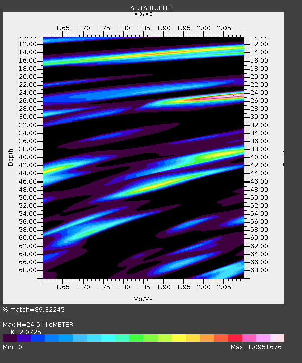
| Estimated Moho Depth: |
24.5 km |
| Estimated Crust Vp/Vs: |
2.07 |
| Assumed Crust Vp: |
6.566 km/s |
| Estimated Crust Vs: |
3.168 km/s |
| Estimated Crust Poisson's Ratio: |
0.35 |
|
| Radial Match: |
89.32245 % |
| Radial Bump: |
400 |
| Transverse Match: |
64.35294 % |
| Transverse Bump: |
400 |
| SOD ConfigId: |
7422571 |
| Insert Time: |
2019-04-20 01:02:21.631 +0000 |
| GWidth: |
2.5 |
| Max Bumps: |
400 |
| Tol: |
0.001 |
|

Signal To Noise
| Channel | StoN | STA | LTA |
| AK:TABL: :BHZ:20150727T21:53:32.468008Z | 17.402348 | 2.2633087E-6 | 1.3005767E-7 |
| AK:TABL: :BHN:20150727T21:53:32.468008Z | 0.8243943 | 2.0221755E-6 | 2.452923E-6 |
| AK:TABL: :BHE:20150727T21:53:32.468008Z | 0.79492027 | 7.1404156E-7 | 8.9825556E-7 |
| Arrivals |
| Ps | 4.1 SECOND |
| PpPs | 11 SECOND |
| PsPs/PpSs | 15 SECOND |


