You are here: Home > Network List > AV - Alaska Volcano Observatory Stations List
> Station AUSS Augustine Summit Station, Augustine Volcano, Alaska > Earthquake Result Viewer
AUSS Augustine Summit Station, Augustine Volcano, Alaska - Earthquake Result Viewer
| Earthquake location: |
Irian Jaya, Indonesia |
| Earthquake latitude/longitude: |
-2.7/138.5 |
| Earthquake time(UTC): |
2015/07/27 (208) 21:41:22 GMT |
| Earthquake Depth: |
53 km |
| Earthquake Magnitude: |
7.0 MWP, 7.0 MI |
| Earthquake Catalog/Contributor: |
NEIC PDE/NEIC COMCAT |
|
| Network: |
AV Alaska Volcano Observatory |
| Station: |
AUSS Augustine Summit Station, Augustine Volcano, Alaska |
| Lat/Lon: |
59.36 N/153.43 W |
| Elevation: |
1235 m |
|
| Distance: |
81.3 deg |
| Az: |
28.731 deg |
| Baz: |
249.635 deg |
| Ray Param: |
0.047571067 |
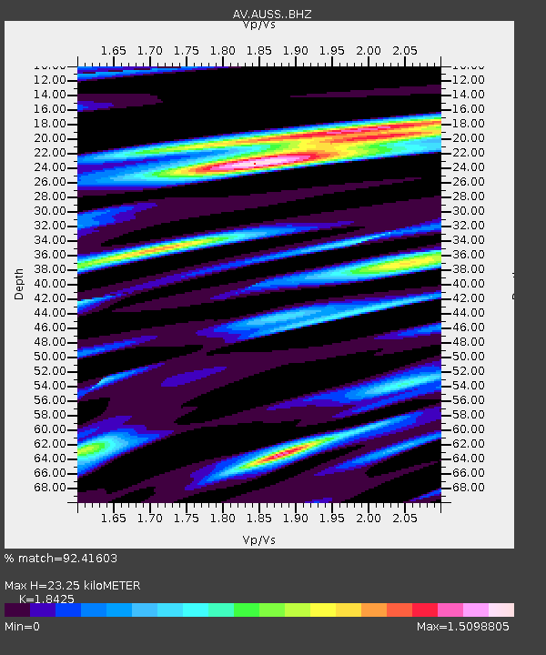
| Estimated Moho Depth: |
23.25 km |
| Estimated Crust Vp/Vs: |
1.84 |
| Assumed Crust Vp: |
5.989 km/s |
| Estimated Crust Vs: |
3.251 km/s |
| Estimated Crust Poisson's Ratio: |
0.29 |
|
| Radial Match: |
92.41603 % |
| Radial Bump: |
371 |
| Transverse Match: |
93.74689 % |
| Transverse Bump: |
371 |
| SOD ConfigId: |
7422571 |
| Insert Time: |
2019-04-20 01:02:39.977 +0000 |
| GWidth: |
2.5 |
| Max Bumps: |
400 |
| Tol: |
0.001 |
|
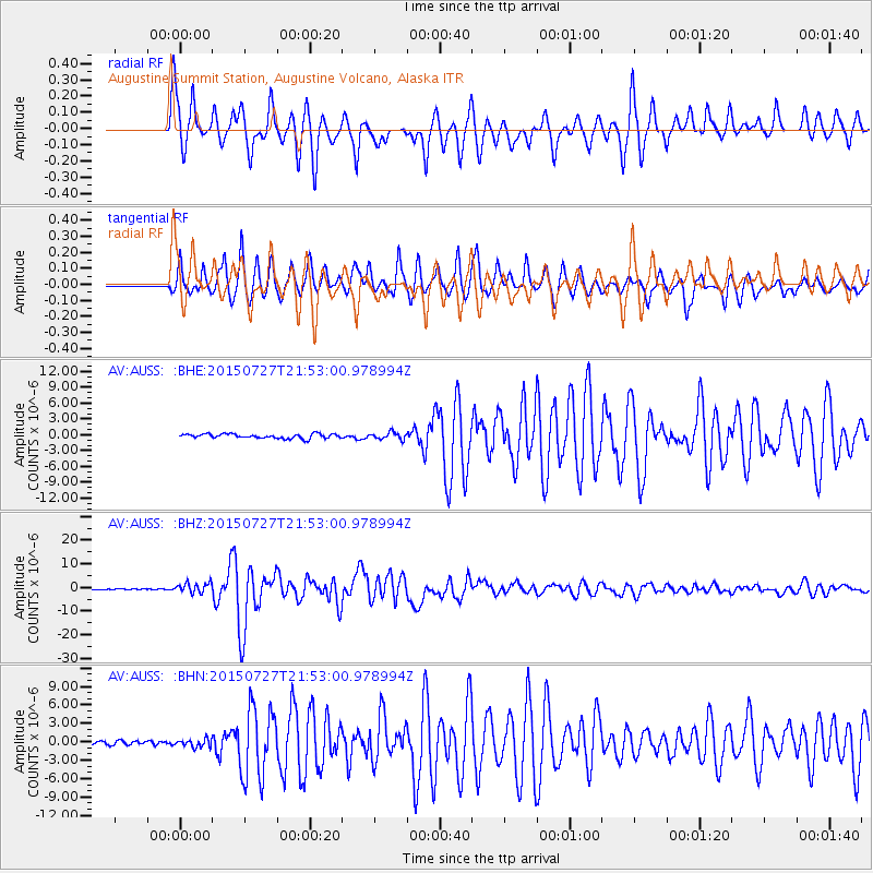
Signal To Noise
| Channel | StoN | STA | LTA |
| AV:AUSS: :BHZ:20150727T21:53:00.978994Z | 15.933372 | 2.1169658E-6 | 1.3286365E-7 |
| AV:AUSS: :BHN:20150727T21:53:00.978994Z | 2.0924792 | 6.28359E-7 | 3.00294E-7 |
| AV:AUSS: :BHE:20150727T21:53:00.978994Z | 1.8510587 | 7.825996E-7 | 4.2278486E-7 |
| Arrivals |
| Ps | 3.3 SECOND |
| PpPs | 11 SECOND |
| PsPs/PpSs | 14 SECOND |


