You are here: Home > Network List > CB - China National Seismic Network Stations List
> Station HEH Heihe,Heilongjiang Province > Earthquake Result Viewer
HEH Heihe,Heilongjiang Province - Earthquake Result Viewer
| Earthquake location: |
Irian Jaya, Indonesia |
| Earthquake latitude/longitude: |
-2.7/138.5 |
| Earthquake time(UTC): |
2015/07/27 (208) 21:41:22 GMT |
| Earthquake Depth: |
53 km |
| Earthquake Magnitude: |
7.0 MWP, 7.0 MI |
| Earthquake Catalog/Contributor: |
NEIC PDE/NEIC COMCAT |
|
| Network: |
CB China National Seismic Network |
| Station: |
HEH Heihe,Heilongjiang Province |
| Lat/Lon: |
50.25 N/127.41 E |
| Elevation: |
165 m |
|
| Distance: |
53.6 deg |
| Az: |
351.191 deg |
| Baz: |
166.214 deg |
| Ray Param: |
0.065861456 |
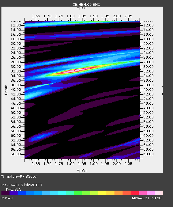
| Estimated Moho Depth: |
31.5 km |
| Estimated Crust Vp/Vs: |
1.82 |
| Assumed Crust Vp: |
6.419 km/s |
| Estimated Crust Vs: |
3.537 km/s |
| Estimated Crust Poisson's Ratio: |
0.28 |
|
| Radial Match: |
97.85057 % |
| Radial Bump: |
185 |
| Transverse Match: |
84.479546 % |
| Transverse Bump: |
340 |
| SOD ConfigId: |
7422571 |
| Insert Time: |
2019-04-20 01:03:11.918 +0000 |
| GWidth: |
2.5 |
| Max Bumps: |
400 |
| Tol: |
0.001 |
|

Signal To Noise
| Channel | StoN | STA | LTA |
| CB:HEH:00:BHZ:20150727T21:50:06.660024Z | 25.23993 | 6.923727E-6 | 2.7431645E-7 |
| CB:HEH:00:BHN:20150727T21:50:06.660024Z | 21.174442 | 3.3661108E-6 | 1.5897047E-7 |
| CB:HEH:00:BHE:20150727T21:50:06.660024Z | 28.851675 | 8.6936296E-7 | 3.013215E-8 |
| Arrivals |
| Ps | 4.2 SECOND |
| PpPs | 13 SECOND |
| PsPs/PpSs | 17 SECOND |


