You are here: Home > Network List > JP - Japan Meteorological Agency Seismic Network Stations List
> Station JHS Hiroshima Saijyo > Earthquake Result Viewer
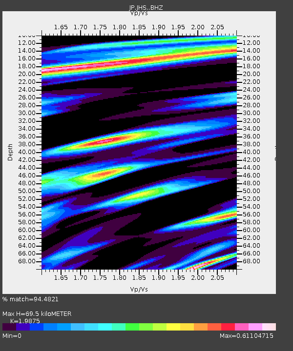
JHS Hiroshima Saijyo - Earthquake Result Viewer
| Earthquake location: |
Irian Jaya, Indonesia |
| Earthquake latitude/longitude: |
-2.7/138.5 |
| Earthquake time(UTC): |
2015/07/27 (208) 21:41:22 GMT |
| Earthquake Depth: |
53 km |
| Earthquake Magnitude: |
7.0 MWP, 7.0 MI |
| Earthquake Catalog/Contributor: |
NEIC PDE/NEIC COMCAT |
|
| Network: |
JP Japan Meteorological Agency Seismic Network |
| Station: |
JHS Hiroshima Saijyo |
| Lat/Lon: |
35.00 N/133.11 E |
| Elevation: |
470 m |
|
| Distance: |
37.8 deg |
| Az: |
352.81 deg |
| Baz: |
171.24 deg |
| Ray Param: |
0.07577015 |
| Estimated Moho Depth: |
69.5 km |
| Estimated Crust Vp/Vs: |
1.99 |
| Assumed Crust Vp: |
6.468 km/s |
| Estimated Crust Vs: |
3.254 km/s |
| Estimated Crust Poisson's Ratio: |
0.33 |
|
| Radial Match: |
94.4821 % |
| Radial Bump: |
332 |
| Transverse Match: |
84.83907 % |
| Transverse Bump: |
400 |
| SOD ConfigId: |
7422571 |
| Insert Time: |
2019-04-20 01:03:59.118 +0000 |
| GWidth: |
2.5 |
| Max Bumps: |
400 |
| Tol: |
0.001 |
|

Signal To Noise
| Channel | StoN | STA | LTA |
| JP:JHS: :BHZ:20150727T21:48:02.599996Z | 29.902788 | 4.61019E-6 | 1.5417257E-7 |
| JP:JHS: :BHN:20150727T21:48:02.599996Z | 33.72769 | 2.7405765E-6 | 8.1255976E-8 |
| JP:JHS: :BHE:20150727T21:48:02.599996Z | 6.9474077 | 7.993253E-7 | 1.15053744E-7 |
| Arrivals |
| Ps | 11 SECOND |
| PpPs | 30 SECOND |
| PsPs/PpSs | 41 SECOND |


