You are here: Home > Network List > TA - USArray Transportable Network (new EarthScope stations) Stations List
> Station G03D McMinnville, OR, USA > Earthquake Result Viewer
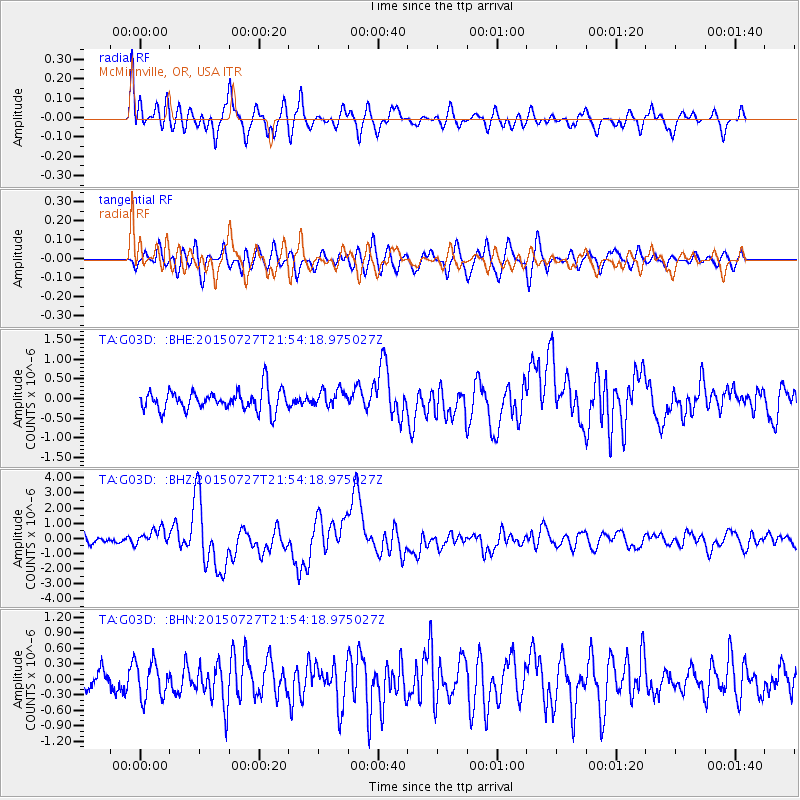
G03D McMinnville, OR, USA - Earthquake Result Viewer
*The percent match for this event was below the threshold and hence no stack was calculated.
| Earthquake location: |
Irian Jaya, Indonesia |
| Earthquake latitude/longitude: |
-2.7/138.5 |
| Earthquake time(UTC): |
2015/07/27 (208) 21:41:22 GMT |
| Earthquake Depth: |
53 km |
| Earthquake Magnitude: |
7.0 MWP, 7.0 MI |
| Earthquake Catalog/Contributor: |
NEIC PDE/NEIC COMCAT |
|
| Network: |
TA USArray Transportable Network (new EarthScope stations) |
| Station: |
G03D McMinnville, OR, USA |
| Lat/Lon: |
45.21 N/123.26 W |
| Elevation: |
222 m |
|
| Distance: |
97.7 deg |
| Az: |
44.906 deg |
| Baz: |
273.965 deg |
| Ray Param: |
$rayparam |
*The percent match for this event was below the threshold and hence was not used in the summary stack. |
|
| Radial Match: |
75.64899 % |
| Radial Bump: |
400 |
| Transverse Match: |
65.76238 % |
| Transverse Bump: |
400 |
| SOD ConfigId: |
7422571 |
| Insert Time: |
2019-04-20 01:05:16.599 +0000 |
| GWidth: |
2.5 |
| Max Bumps: |
400 |
| Tol: |
0.001 |
|
Signal To Noise
| Channel | StoN | STA | LTA |
| TA:G03D: :BHZ:20150727T21:54:18.975027Z | 2.0830338 | 5.410877E-7 | 2.5975945E-7 |
| TA:G03D: :BHN:20150727T21:54:18.975027Z | 1.6446524 | 3.4361838E-7 | 2.0893071E-7 |
| TA:G03D: :BHE:20150727T21:54:18.975027Z | 0.8752483 | 2.2761624E-7 | 2.6005904E-7 |
| Arrivals |
| Ps | |
| PpPs | |
| PsPs/PpSs | |


