You are here: Home > Network List > TA - USArray Transportable Network (new EarthScope stations) Stations List
> Station H24K Noodor Dome, AK, USA > Earthquake Result Viewer
H24K Noodor Dome, AK, USA - Earthquake Result Viewer

| Earthquake location: |
Irian Jaya, Indonesia |
| Earthquake latitude/longitude: |
-2.7/138.5 |
| Earthquake time(UTC): |
2015/07/27 (208) 21:41:22 GMT |
| Earthquake Depth: |
53 km |
| Earthquake Magnitude: |
7.0 MWP, 7.0 MI |
| Earthquake Catalog/Contributor: |
NEIC PDE/NEIC COMCAT |
|
| Network: |
TA USArray Transportable Network (new EarthScope stations) |
| Station: |
H24K Noodor Dome, AK, USA |
| Lat/Lon: |
65.84 N/147.88 W |
| Elevation: |
814 m |
|
| Distance: |
85.8 deg |
| Az: |
23.33 deg |
| Baz: |
253.96 deg |
| Ray Param: |
0.044417057 |
| Estimated Moho Depth: |
32.75 km |
| Estimated Crust Vp/Vs: |
1.71 |
| Assumed Crust Vp: |
6.566 km/s |
| Estimated Crust Vs: |
3.851 km/s |
| Estimated Crust Poisson's Ratio: |
0.24 |
|
| Radial Match: |
96.66768 % |
| Radial Bump: |
298 |
| Transverse Match: |
96.26667 % |
| Transverse Bump: |
254 |
| SOD ConfigId: |
7422571 |
| Insert Time: |
2019-04-20 01:05:16.847 +0000 |
| GWidth: |
2.5 |
| Max Bumps: |
400 |
| Tol: |
0.001 |
|
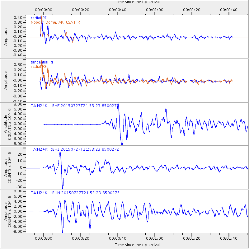
Signal To Noise
| Channel | StoN | STA | LTA |
| TA:H24K: :BHZ:20150727T21:53:23.850027Z | 27.724396 | 1.8268296E-6 | 6.589249E-8 |
| TA:H24K: :BHN:20150727T21:53:23.850027Z | 9.589455 | 3.5075257E-7 | 3.6576903E-8 |
| TA:H24K: :BHE:20150727T21:53:23.850027Z | 10.713458 | 5.782141E-7 | 5.397082E-8 |
| Arrivals |
| Ps | 3.6 SECOND |
| PpPs | 13 SECOND |
| PsPs/PpSs | 17 SECOND |


