You are here: Home > Network List > TM - Thai Seismic Monitoring Network Stations List
> Station SKLT SKLT SongKhla Phase1 > Earthquake Result Viewer
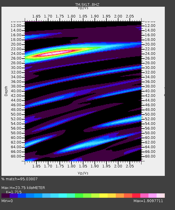
SKLT SKLT SongKhla Phase1 - Earthquake Result Viewer
| Earthquake location: |
Irian Jaya, Indonesia |
| Earthquake latitude/longitude: |
-2.7/138.5 |
| Earthquake time(UTC): |
2015/07/27 (208) 21:41:22 GMT |
| Earthquake Depth: |
53 km |
| Earthquake Magnitude: |
7.0 MWP, 7.0 MI |
| Earthquake Catalog/Contributor: |
NEIC PDE/NEIC COMCAT |
|
| Network: |
TM Thai Seismic Monitoring Network |
| Station: |
SKLT SKLT SongKhla Phase1 |
| Lat/Lon: |
7.18 N/100.62 E |
| Elevation: |
4.0 m |
|
| Distance: |
39.0 deg |
| Az: |
284.762 deg |
| Baz: |
103.228 deg |
| Ray Param: |
0.07507492 |
| Estimated Moho Depth: |
23.75 km |
| Estimated Crust Vp/Vs: |
1.72 |
| Assumed Crust Vp: |
6.468 km/s |
| Estimated Crust Vs: |
3.771 km/s |
| Estimated Crust Poisson's Ratio: |
0.24 |
|
| Radial Match: |
95.03807 % |
| Radial Bump: |
247 |
| Transverse Match: |
83.50827 % |
| Transverse Bump: |
400 |
| SOD ConfigId: |
7422571 |
| Insert Time: |
2019-04-20 01:05:50.066 +0000 |
| GWidth: |
2.5 |
| Max Bumps: |
400 |
| Tol: |
0.001 |
|

Signal To Noise
| Channel | StoN | STA | LTA |
| TM:SKLT: :BHZ:20150727T21:48:13.02001Z | 74.30094 | 6.543798E-6 | 8.8071545E-8 |
| TM:SKLT: :BHN:20150727T21:48:13.02001Z | 12.145788 | 8.912148E-7 | 7.337645E-8 |
| TM:SKLT: :BHE:20150727T21:48:13.02001Z | 51.270424 | 4.3839436E-6 | 8.550629E-8 |
| Arrivals |
| Ps | 2.8 SECOND |
| PpPs | 9.3 SECOND |
| PsPs/PpSs | 12 SECOND |


