You are here: Home > Network List > XD14 - Illuminating the architecture of the greater Mount St. Helens magmatic systems f Stations List
> Station MJ01 "Mount St Helens, WA" > Earthquake Result Viewer
MJ01 "Mount St Helens, WA" - Earthquake Result Viewer
| Earthquake location: |
Irian Jaya, Indonesia |
| Earthquake latitude/longitude: |
-2.7/138.5 |
| Earthquake time(UTC): |
2015/07/27 (208) 21:41:22 GMT |
| Earthquake Depth: |
53 km |
| Earthquake Magnitude: |
7.0 MWP, 7.0 MI |
| Earthquake Catalog/Contributor: |
NEIC PDE/NEIC COMCAT |
|
| Network: |
XD Illuminating the architecture of the greater Mount St. Helens magmatic systems f |
| Station: |
MJ01 "Mount St Helens, WA" |
| Lat/Lon: |
46.19 N/122.81 W |
| Elevation: |
339 m |
|
| Distance: |
98.0 deg |
| Az: |
43.894 deg |
| Baz: |
274.426 deg |
| Ray Param: |
0.040014833 |
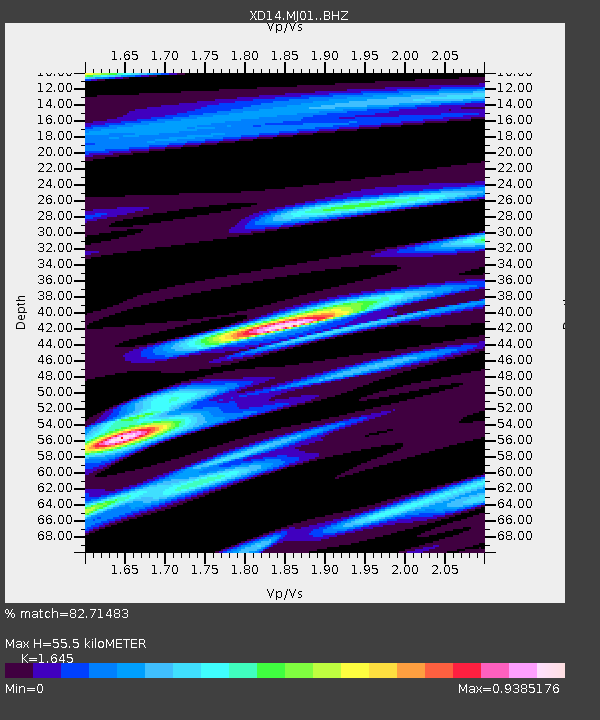
| Estimated Moho Depth: |
55.5 km |
| Estimated Crust Vp/Vs: |
1.64 |
| Assumed Crust Vp: |
6.566 km/s |
| Estimated Crust Vs: |
3.992 km/s |
| Estimated Crust Poisson's Ratio: |
0.21 |
|
| Radial Match: |
82.71483 % |
| Radial Bump: |
400 |
| Transverse Match: |
68.450775 % |
| Transverse Bump: |
400 |
| SOD ConfigId: |
7422571 |
| Insert Time: |
2019-04-20 01:06:11.767 +0000 |
| GWidth: |
2.5 |
| Max Bumps: |
400 |
| Tol: |
0.001 |
|

Signal To Noise
| Channel | StoN | STA | LTA |
| XD:MJ01: :BHZ:20150727T21:54:20.064993Z | 3.1929548 | 4.8573827E-7 | 1.5212814E-7 |
| XD:MJ01: :BHN:20150727T21:54:20.064993Z | 1.3790331 | 2.9788941E-7 | 2.1601325E-7 |
| XD:MJ01: :BHE:20150727T21:54:20.064993Z | 0.7031601 | 1.802514E-7 | 2.5634475E-7 |
| Arrivals |
| Ps | 5.6 SECOND |
| PpPs | 22 SECOND |
| PsPs/PpSs | 27 SECOND |


