You are here: Home > Network List > XL12 - Hangay Dome, Mongolia Stations List
> Station HV14 HV14 > Earthquake Result Viewer
HV14 HV14 - Earthquake Result Viewer
| Earthquake location: |
Irian Jaya, Indonesia |
| Earthquake latitude/longitude: |
-2.7/138.5 |
| Earthquake time(UTC): |
2015/07/27 (208) 21:41:22 GMT |
| Earthquake Depth: |
53 km |
| Earthquake Magnitude: |
7.0 MWP, 7.0 MI |
| Earthquake Catalog/Contributor: |
NEIC PDE/NEIC COMCAT |
|
| Network: |
XL Hangay Dome, Mongolia |
| Station: |
HV14 HV14 |
| Lat/Lon: |
50.46 N/100.17 E |
| Elevation: |
1663 m |
|
| Distance: |
62.3 deg |
| Az: |
333.408 deg |
| Baz: |
135.611 deg |
| Ray Param: |
0.060211256 |
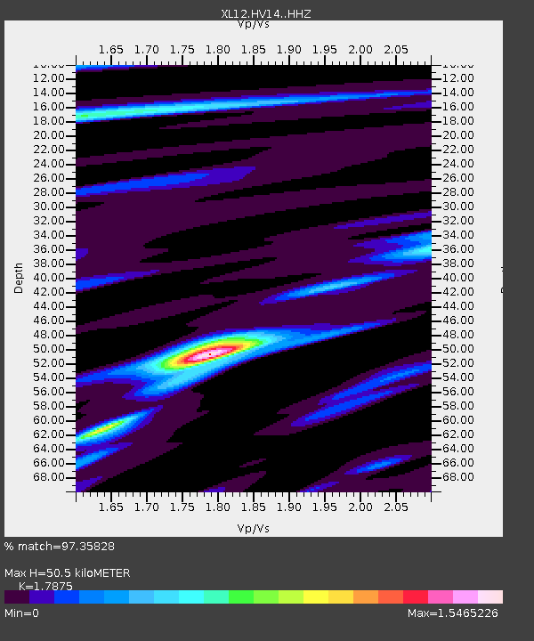
| Estimated Moho Depth: |
50.5 km |
| Estimated Crust Vp/Vs: |
1.79 |
| Assumed Crust Vp: |
6.419 km/s |
| Estimated Crust Vs: |
3.591 km/s |
| Estimated Crust Poisson's Ratio: |
0.27 |
|
| Radial Match: |
97.35828 % |
| Radial Bump: |
306 |
| Transverse Match: |
90.579124 % |
| Transverse Bump: |
400 |
| SOD ConfigId: |
7422571 |
| Insert Time: |
2019-04-20 01:06:36.475 +0000 |
| GWidth: |
2.5 |
| Max Bumps: |
400 |
| Tol: |
0.001 |
|

Signal To Noise
| Channel | StoN | STA | LTA |
| XL:HV14: :HHZ:20150727T21:51:07.468984Z | 59.904324 | 3.3629397E-6 | 5.6138514E-8 |
| XL:HV14: :HHN:20150727T21:51:07.468984Z | 39.331017 | 1.1775741E-6 | 2.9940086E-8 |
| XL:HV14: :HHE:20150727T21:51:07.468984Z | 39.91747 | 1.1269426E-6 | 2.8231817E-8 |
| Arrivals |
| Ps | 6.5 SECOND |
| PpPs | 21 SECOND |
| PsPs/PpSs | 27 SECOND |


