You are here: Home > Network List > ZJ12 - Transantarctic Mountains Northern Network Stations List
> Station DUBY Mt Kring, Antarctica > Earthquake Result Viewer
DUBY Mt Kring, Antarctica - Earthquake Result Viewer
| Earthquake location: |
Irian Jaya, Indonesia |
| Earthquake latitude/longitude: |
-2.7/138.5 |
| Earthquake time(UTC): |
2015/07/27 (208) 21:41:22 GMT |
| Earthquake Depth: |
53 km |
| Earthquake Magnitude: |
7.0 MWP, 7.0 MI |
| Earthquake Catalog/Contributor: |
NEIC PDE/NEIC COMCAT |
|
| Network: |
ZJ Transantarctic Mountains Northern Network |
| Station: |
DUBY Mt Kring, Antarctica |
| Lat/Lon: |
74.99 S/158.08 E |
| Elevation: |
1508 m |
|
| Distance: |
73.1 deg |
| Az: |
174.757 deg |
| Baz: |
339.504 deg |
| Ray Param: |
0.05310904 |
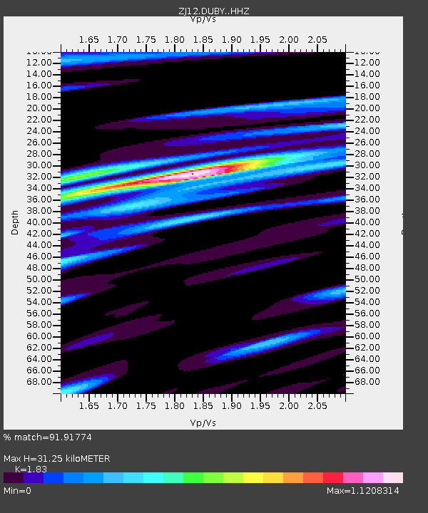
| Estimated Moho Depth: |
31.25 km |
| Estimated Crust Vp/Vs: |
1.83 |
| Assumed Crust Vp: |
6.182 km/s |
| Estimated Crust Vs: |
3.378 km/s |
| Estimated Crust Poisson's Ratio: |
0.29 |
|
| Radial Match: |
91.91774 % |
| Radial Bump: |
400 |
| Transverse Match: |
89.849915 % |
| Transverse Bump: |
400 |
| SOD ConfigId: |
7422571 |
| Insert Time: |
2019-04-20 01:07:43.109 +0000 |
| GWidth: |
2.5 |
| Max Bumps: |
400 |
| Tol: |
0.001 |
|

Signal To Noise
| Channel | StoN | STA | LTA |
| ZJ:DUBY: :HHZ:20150727T21:52:15.080007Z | 3.9448311 | 1.7935217E-6 | 4.5465106E-7 |
| ZJ:DUBY: :HHN:20150727T21:52:15.080007Z | 1.193299 | 4.4853502E-7 | 3.7587813E-7 |
| ZJ:DUBY: :HHE:20150727T21:52:15.080007Z | 2.5388834 | 7.87217E-7 | 3.1006425E-7 |
| Arrivals |
| Ps | 4.3 SECOND |
| PpPs | 14 SECOND |
| PsPs/PpSs | 18 SECOND |


