You are here: Home > Network List > TA - USArray Transportable Network (new EarthScope stations) Stations List
> Station G03D McMinnville, OR, USA > Earthquake Result Viewer
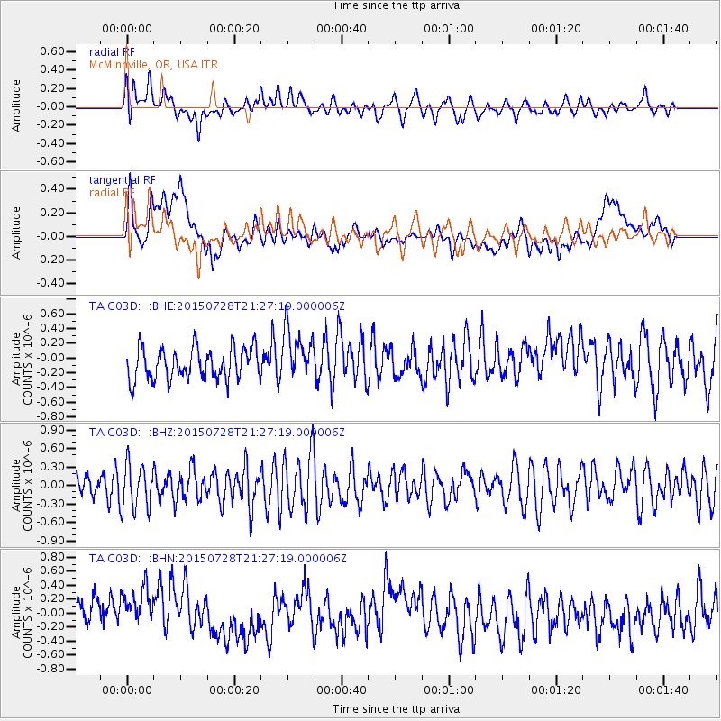
G03D McMinnville, OR, USA - Earthquake Result Viewer
*The percent match for this event was below the threshold and hence no stack was calculated.
| Earthquake location: |
Fox Islands, Aleutian Islands |
| Earthquake latitude/longitude: |
52.1/-169.4 |
| Earthquake time(UTC): |
2015/07/28 (209) 21:21:33 GMT |
| Earthquake Depth: |
12 km |
| Earthquake Magnitude: |
5.4 MW |
| Earthquake Catalog/Contributor: |
ISC/ISC |
|
| Network: |
TA USArray Transportable Network (new EarthScope stations) |
| Station: |
G03D McMinnville, OR, USA |
| Lat/Lon: |
45.21 N/123.26 W |
| Elevation: |
222 m |
|
| Distance: |
30.8 deg |
| Az: |
84.23 deg |
| Baz: |
299.669 deg |
| Ray Param: |
$rayparam |
*The percent match for this event was below the threshold and hence was not used in the summary stack. |
|
| Radial Match: |
48.3269 % |
| Radial Bump: |
400 |
| Transverse Match: |
39.540726 % |
| Transverse Bump: |
400 |
| SOD ConfigId: |
7422571 |
| Insert Time: |
2019-04-20 01:24:10.871 +0000 |
| GWidth: |
2.5 |
| Max Bumps: |
400 |
| Tol: |
0.001 |
|
Signal To Noise
| Channel | StoN | STA | LTA |
| TA:G03D: :BHZ:20150728T21:27:19.000006Z | 1.8222429 | 3.540018E-7 | 1.9426707E-7 |
| TA:G03D: :BHN:20150728T21:27:19.000006Z | 1.6718996 | 3.818654E-7 | 2.2840211E-7 |
| TA:G03D: :BHE:20150728T21:27:19.000006Z | 1.6562645 | 3.5405958E-7 | 2.1376995E-7 |
| Arrivals |
| Ps | |
| PpPs | |
| PsPs/PpSs | |


