You are here: Home > Network List > US - United States National Seismic Network Stations List
> Station WVOR Wild Horse Valley, Oregon, USA > Earthquake Result Viewer
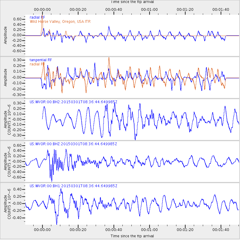
WVOR Wild Horse Valley, Oregon, USA - Earthquake Result Viewer
*The percent match for this event was below the threshold and hence no stack was calculated.
| Earthquake location: |
Near Coast Of Guatemala |
| Earthquake latitude/longitude: |
13.4/-91.0 |
| Earthquake time(UTC): |
2015/03/01 (060) 08:30:03 GMT |
| Earthquake Depth: |
20 km |
| Earthquake Magnitude: |
5.5 MWW, 5.2 MWB, 5.5 MWC |
| Earthquake Catalog/Contributor: |
NEIC PDE/NEIC COMCAT |
|
| Network: |
US United States National Seismic Network |
| Station: |
WVOR Wild Horse Valley, Oregon, USA |
| Lat/Lon: |
42.43 N/118.64 W |
| Elevation: |
1344 m |
|
| Distance: |
37.5 deg |
| Az: |
325.654 deg |
| Baz: |
132.142 deg |
| Ray Param: |
$rayparam |
*The percent match for this event was below the threshold and hence was not used in the summary stack. |
|
| Radial Match: |
45.845432 % |
| Radial Bump: |
314 |
| Transverse Match: |
54.033745 % |
| Transverse Bump: |
356 |
| SOD ConfigId: |
872571 |
| Insert Time: |
2015-04-11 06:11:29.752 +0000 |
| GWidth: |
2.5 |
| Max Bumps: |
400 |
| Tol: |
0.001 |
|
Signal To Noise
| Channel | StoN | STA | LTA |
| US:WVOR:00:BHZ:20150301T08:36:44.649985Z | 2.3405526 | 2.3469447E-7 | 1.002731E-7 |
| US:WVOR:00:BH1:20150301T08:36:44.649985Z | 1.1306957 | 1.07087416E-7 | 9.4709314E-8 |
| US:WVOR:00:BH2:20150301T08:36:44.649985Z | 1.5445626 | 1.7740432E-7 | 1.14857315E-7 |
| Arrivals |
| Ps | |
| PpPs | |
| PsPs/PpSs | |


