You are here: Home > Network List > AV - Alaska Volcano Observatory Stations List
> Station SPCP Crater Peak Broadband, Mount Spurr, Alaska > Earthquake Result Viewer
SPCP Crater Peak Broadband, Mount Spurr, Alaska - Earthquake Result Viewer
| Earthquake location: |
Panama-Colombia Border Region |
| Earthquake latitude/longitude: |
8.2/-77.3 |
| Earthquake time(UTC): |
2015/07/29 (210) 00:10:24 GMT |
| Earthquake Depth: |
10 km |
| Earthquake Magnitude: |
5.9 MWP, 6.1 MI |
| Earthquake Catalog/Contributor: |
NEIC PDE/NEIC COMCAT |
|
| Network: |
AV Alaska Volcano Observatory |
| Station: |
SPCP Crater Peak Broadband, Mount Spurr, Alaska |
| Lat/Lon: |
61.27 N/152.15 W |
| Elevation: |
1616 m |
|
| Distance: |
75.5 deg |
| Az: |
331.204 deg |
| Baz: |
99.367 deg |
| Ray Param: |
0.051594485 |
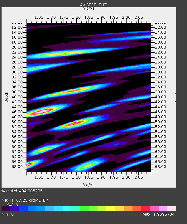
| Estimated Moho Depth: |
67.25 km |
| Estimated Crust Vp/Vs: |
1.60 |
| Assumed Crust Vp: |
6.566 km/s |
| Estimated Crust Vs: |
4.104 km/s |
| Estimated Crust Poisson's Ratio: |
0.18 |
|
| Radial Match: |
84.085785 % |
| Radial Bump: |
400 |
| Transverse Match: |
79.765114 % |
| Transverse Bump: |
400 |
| SOD ConfigId: |
7422571 |
| Insert Time: |
2019-04-20 01:29:46.532 +0000 |
| GWidth: |
2.5 |
| Max Bumps: |
400 |
| Tol: |
0.001 |
|

Signal To Noise
| Channel | StoN | STA | LTA |
| AV:SPCP: :BHZ:20150729T00:21:36.540024Z | 4.894592 | 8.139961E-7 | 1.6630521E-7 |
| AV:SPCP: :BHN:20150729T00:21:36.540024Z | 4.306757 | 5.878623E-7 | 1.3649768E-7 |
| AV:SPCP: :BHE:20150729T00:21:36.540024Z | 3.3873942 | 4.768356E-7 | 1.4076767E-7 |
| Arrivals |
| Ps | 6.4 SECOND |
| PpPs | 26 SECOND |
| PsPs/PpSs | 32 SECOND |


