You are here: Home > Network List > CI - Caltech Regional Seismic Network Stations List
> Station DEC Green Verdugo Microwave Site, Sunland, CA, USA > Earthquake Result Viewer
DEC Green Verdugo Microwave Site, Sunland, CA, USA - Earthquake Result Viewer
| Earthquake location: |
Panama-Colombia Border Region |
| Earthquake latitude/longitude: |
8.2/-77.3 |
| Earthquake time(UTC): |
2015/07/29 (210) 00:10:24 GMT |
| Earthquake Depth: |
10 km |
| Earthquake Magnitude: |
5.9 MWP, 6.1 MI |
| Earthquake Catalog/Contributor: |
NEIC PDE/NEIC COMCAT |
|
| Network: |
CI Caltech Regional Seismic Network |
| Station: |
DEC Green Verdugo Microwave Site, Sunland, CA, USA |
| Lat/Lon: |
34.25 N/118.33 W |
| Elevation: |
519 m |
|
| Distance: |
45.7 deg |
| Az: |
310.572 deg |
| Baz: |
114.811 deg |
| Ray Param: |
0.071092635 |
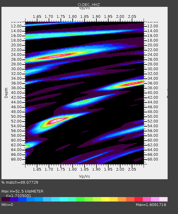
| Estimated Moho Depth: |
51.5 km |
| Estimated Crust Vp/Vs: |
1.73 |
| Assumed Crust Vp: |
6.1 km/s |
| Estimated Crust Vs: |
3.521 km/s |
| Estimated Crust Poisson's Ratio: |
0.25 |
|
| Radial Match: |
89.07729 % |
| Radial Bump: |
400 |
| Transverse Match: |
82.20269 % |
| Transverse Bump: |
400 |
| SOD ConfigId: |
7422571 |
| Insert Time: |
2019-04-20 01:30:56.766 +0000 |
| GWidth: |
2.5 |
| Max Bumps: |
400 |
| Tol: |
0.001 |
|

Signal To Noise
| Channel | StoN | STA | LTA |
| CI:DEC: :HHZ:20150729T00:18:13.418015Z | 6.696877 | 1.4585623E-6 | 2.1779739E-7 |
| CI:DEC: :HHN:20150729T00:18:13.418015Z | 1.7935438 | 5.784901E-7 | 3.2254027E-7 |
| CI:DEC: :HHE:20150729T00:18:13.418015Z | 2.8759832 | 8.826102E-7 | 3.0688992E-7 |
| Arrivals |
| Ps | 6.6 SECOND |
| PpPs | 22 SECOND |
| PsPs/PpSs | 28 SECOND |


