You are here: Home > Network List > CI - Caltech Regional Seismic Network Stations List
> Station SMM Simmler, CA, USA > Earthquake Result Viewer
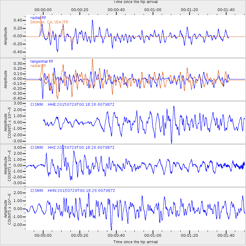
SMM Simmler, CA, USA - Earthquake Result Viewer
*The percent match for this event was below the threshold and hence no stack was calculated.
| Earthquake location: |
Panama-Colombia Border Region |
| Earthquake latitude/longitude: |
8.2/-77.3 |
| Earthquake time(UTC): |
2015/07/29 (210) 00:10:24 GMT |
| Earthquake Depth: |
10 km |
| Earthquake Magnitude: |
5.9 MWP, 6.1 MI |
| Earthquake Catalog/Contributor: |
NEIC PDE/NEIC COMCAT |
|
| Network: |
CI Caltech Regional Seismic Network |
| Station: |
SMM Simmler, CA, USA |
| Lat/Lon: |
35.31 N/120.00 W |
| Elevation: |
599 m |
|
| Distance: |
47.4 deg |
| Az: |
311.116 deg |
| Baz: |
114.241 deg |
| Ray Param: |
$rayparam |
*The percent match for this event was below the threshold and hence was not used in the summary stack. |
|
| Radial Match: |
66.37044 % |
| Radial Bump: |
400 |
| Transverse Match: |
54.122646 % |
| Transverse Bump: |
400 |
| SOD ConfigId: |
7422571 |
| Insert Time: |
2019-04-20 01:31:26.419 +0000 |
| GWidth: |
2.5 |
| Max Bumps: |
400 |
| Tol: |
0.001 |
|
Signal To Noise
| Channel | StoN | STA | LTA |
| CI:SMM: :HHZ:20150729T00:18:26.607987Z | 4.0917873 | 9.647381E-7 | 2.3577425E-7 |
| CI:SMM: :HHN:20150729T00:18:26.607987Z | 1.9241167 | 5.980513E-7 | 3.1081862E-7 |
| CI:SMM: :HHE:20150729T00:18:26.607987Z | 2.4211028 | 9.385192E-7 | 3.876412E-7 |
| Arrivals |
| Ps | |
| PpPs | |
| PsPs/PpSs | |


