You are here: Home > Network List > CN - Canadian National Seismograph Network Stations List
> Station MALO Mcalpine Lake, ON, CA > Earthquake Result Viewer
MALO Mcalpine Lake, ON, CA - Earthquake Result Viewer
| Earthquake location: |
Panama-Colombia Border Region |
| Earthquake latitude/longitude: |
8.2/-77.3 |
| Earthquake time(UTC): |
2015/07/29 (210) 00:10:24 GMT |
| Earthquake Depth: |
10 km |
| Earthquake Magnitude: |
5.9 MWP, 6.1 MI |
| Earthquake Catalog/Contributor: |
NEIC PDE/NEIC COMCAT |
|
| Network: |
CN Canadian National Seismograph Network |
| Station: |
MALO Mcalpine Lake, ON, CA |
| Lat/Lon: |
50.02 N/79.76 W |
| Elevation: |
271 m |
|
| Distance: |
41.7 deg |
| Az: |
357.61 deg |
| Baz: |
176.331 deg |
| Ray Param: |
0.07362465 |
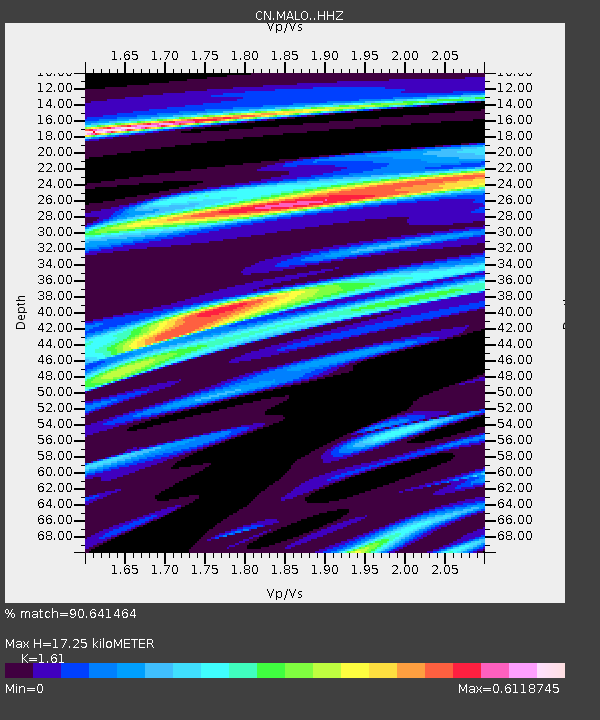
| Estimated Moho Depth: |
17.25 km |
| Estimated Crust Vp/Vs: |
1.61 |
| Assumed Crust Vp: |
6.459 km/s |
| Estimated Crust Vs: |
4.012 km/s |
| Estimated Crust Poisson's Ratio: |
0.19 |
|
| Radial Match: |
90.641464 % |
| Radial Bump: |
230 |
| Transverse Match: |
86.9529 % |
| Transverse Bump: |
220 |
| SOD ConfigId: |
7422571 |
| Insert Time: |
2019-04-20 01:31:49.404 +0000 |
| GWidth: |
2.5 |
| Max Bumps: |
400 |
| Tol: |
0.001 |
|

Signal To Noise
| Channel | StoN | STA | LTA |
| CN:MALO: :HHZ:20150729T00:17:41.560013Z | 4.12238 | 2.9214328E-7 | 7.086763E-8 |
| CN:MALO: :HHN:20150729T00:17:41.560013Z | 2.7291162 | 1.5887288E-7 | 5.8214038E-8 |
| CN:MALO: :HHE:20150729T00:17:41.560013Z | 1.7958506 | 8.2476056E-8 | 4.59259E-8 |
| Arrivals |
| Ps | 1.8 SECOND |
| PpPs | 6.5 SECOND |
| PsPs/PpSs | 8.2 SECOND |


