You are here: Home > Network List > N4 - Central and EAstern US Network Stations List
> Station I37B Waseca, MN, USA > Earthquake Result Viewer
I37B Waseca, MN, USA - Earthquake Result Viewer
| Earthquake location: |
Panama-Colombia Border Region |
| Earthquake latitude/longitude: |
8.2/-77.3 |
| Earthquake time(UTC): |
2015/07/29 (210) 00:10:24 GMT |
| Earthquake Depth: |
10 km |
| Earthquake Magnitude: |
5.9 MWP, 6.1 MI |
| Earthquake Catalog/Contributor: |
NEIC PDE/NEIC COMCAT |
|
| Network: |
N4 Central and EAstern US Network |
| Station: |
I37B Waseca, MN, USA |
| Lat/Lon: |
44.01 N/93.40 W |
| Elevation: |
354 m |
|
| Distance: |
38.3 deg |
| Az: |
341.168 deg |
| Baz: |
153.714 deg |
| Ray Param: |
0.07563634 |
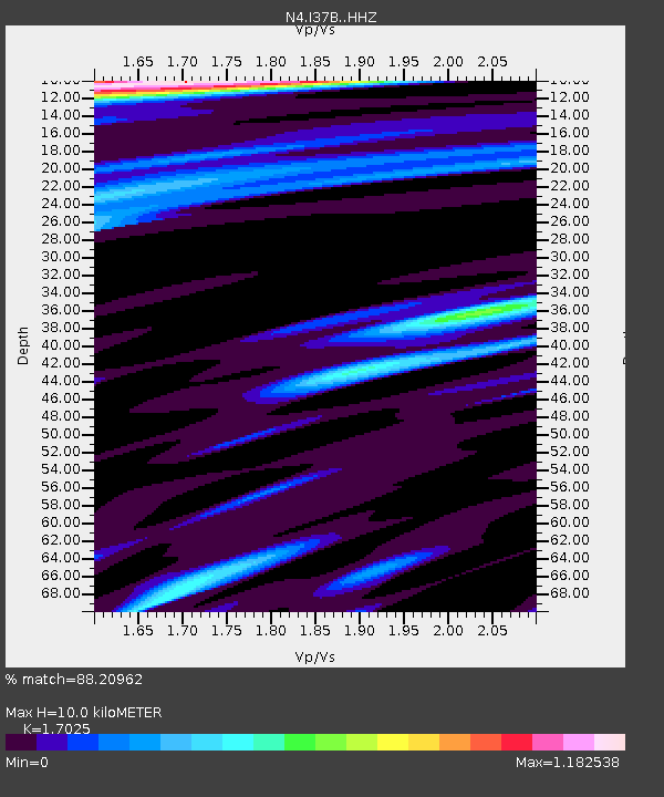
| Estimated Moho Depth: |
10.0 km |
| Estimated Crust Vp/Vs: |
1.70 |
| Assumed Crust Vp: |
6.571 km/s |
| Estimated Crust Vs: |
3.859 km/s |
| Estimated Crust Poisson's Ratio: |
0.24 |
|
| Radial Match: |
88.20962 % |
| Radial Bump: |
388 |
| Transverse Match: |
53.924213 % |
| Transverse Bump: |
400 |
| SOD ConfigId: |
7422571 |
| Insert Time: |
2019-04-20 01:33:38.604 +0000 |
| GWidth: |
2.5 |
| Max Bumps: |
400 |
| Tol: |
0.001 |
|

Signal To Noise
| Channel | StoN | STA | LTA |
| N4:I37B: :HHZ:20150729T00:17:13.330002Z | 7.128464 | 8.088392E-7 | 1.1346613E-7 |
| N4:I37B: :HHN:20150729T00:17:13.330002Z | 2.4772377 | 3.0945304E-7 | 1.2491859E-7 |
| N4:I37B: :HHE:20150729T00:17:13.330002Z | 1.955238 | 1.8520964E-7 | 9.472486E-8 |
| Arrivals |
| Ps | 1.2 SECOND |
| PpPs | 3.8 SECOND |
| PsPs/PpSs | 5.0 SECOND |


