You are here: Home > Network List > N4 - Central and EAstern US Network Stations List
> Station P51A Williamsport, OH, USA > Earthquake Result Viewer
P51A Williamsport, OH, USA - Earthquake Result Viewer
| Earthquake location: |
Panama-Colombia Border Region |
| Earthquake latitude/longitude: |
8.2/-77.3 |
| Earthquake time(UTC): |
2015/07/29 (210) 00:10:24 GMT |
| Earthquake Depth: |
10 km |
| Earthquake Magnitude: |
5.9 MWP, 6.1 MI |
| Earthquake Catalog/Contributor: |
NEIC PDE/NEIC COMCAT |
|
| Network: |
N4 Central and EAstern US Network |
| Station: |
P51A Williamsport, OH, USA |
| Lat/Lon: |
39.48 N/83.06 W |
| Elevation: |
211 m |
|
| Distance: |
31.5 deg |
| Az: |
351.458 deg |
| Baz: |
169.048 deg |
| Ray Param: |
0.07903491 |
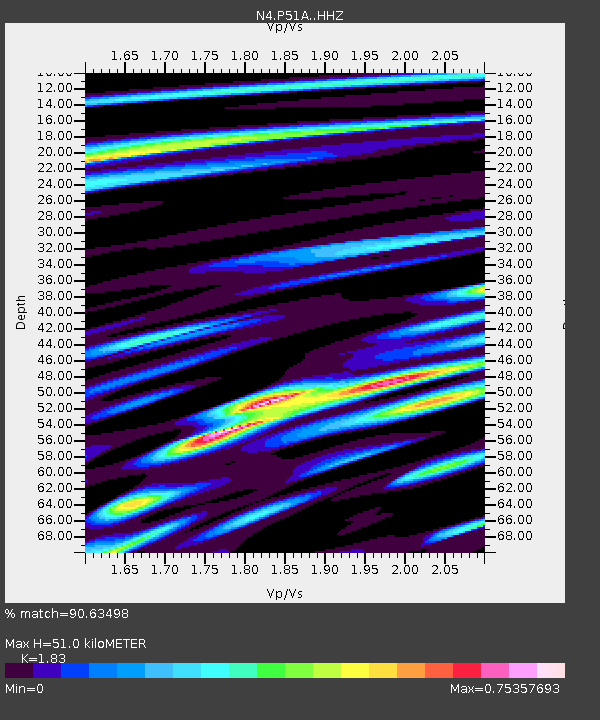
| Estimated Moho Depth: |
51.0 km |
| Estimated Crust Vp/Vs: |
1.83 |
| Assumed Crust Vp: |
6.232 km/s |
| Estimated Crust Vs: |
3.405 km/s |
| Estimated Crust Poisson's Ratio: |
0.29 |
|
| Radial Match: |
90.63498 % |
| Radial Bump: |
365 |
| Transverse Match: |
59.290897 % |
| Transverse Bump: |
400 |
| SOD ConfigId: |
7422571 |
| Insert Time: |
2019-04-20 01:34:10.083 +0000 |
| GWidth: |
2.5 |
| Max Bumps: |
400 |
| Tol: |
0.001 |
|

Signal To Noise
| Channel | StoN | STA | LTA |
| N4:P51A: :HHZ:20150729T00:16:15.169999Z | 5.273245 | 4.413168E-7 | 8.36898E-8 |
| N4:P51A: :HHN:20150729T00:16:15.169999Z | 3.0080276 | 2.8016814E-7 | 9.314016E-8 |
| N4:P51A: :HHE:20150729T00:16:15.169999Z | 1.170356 | 1.0498656E-7 | 8.9704805E-8 |
| Arrivals |
| Ps | 7.3 SECOND |
| PpPs | 22 SECOND |
| PsPs/PpSs | 29 SECOND |


