You are here: Home > Network List > N4 - Central and EAstern US Network Stations List
> Station R32B Long Quarter, Great Bend, KS, USA > Earthquake Result Viewer
R32B Long Quarter, Great Bend, KS, USA - Earthquake Result Viewer
| Earthquake location: |
Panama-Colombia Border Region |
| Earthquake latitude/longitude: |
8.2/-77.3 |
| Earthquake time(UTC): |
2015/07/29 (210) 00:10:24 GMT |
| Earthquake Depth: |
10 km |
| Earthquake Magnitude: |
5.9 MWP, 6.1 MI |
| Earthquake Catalog/Contributor: |
NEIC PDE/NEIC COMCAT |
|
| Network: |
N4 Central and EAstern US Network |
| Station: |
R32B Long Quarter, Great Bend, KS, USA |
| Lat/Lon: |
38.42 N/98.71 W |
| Elevation: |
568 m |
|
| Distance: |
35.7 deg |
| Az: |
330.58 deg |
| Baz: |
141.757 deg |
| Ray Param: |
0.07707252 |
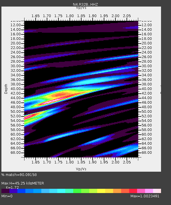
| Estimated Moho Depth: |
45.25 km |
| Estimated Crust Vp/Vs: |
1.72 |
| Assumed Crust Vp: |
6.483 km/s |
| Estimated Crust Vs: |
3.769 km/s |
| Estimated Crust Poisson's Ratio: |
0.24 |
|
| Radial Match: |
90.09158 % |
| Radial Bump: |
350 |
| Transverse Match: |
61.823997 % |
| Transverse Bump: |
400 |
| SOD ConfigId: |
7422571 |
| Insert Time: |
2019-04-20 01:34:16.754 +0000 |
| GWidth: |
2.5 |
| Max Bumps: |
400 |
| Tol: |
0.001 |
|

Signal To Noise
| Channel | StoN | STA | LTA |
| N4:R32B: :HHZ:20150729T00:16:51.259995Z | 8.101008 | 5.9624654E-7 | 7.360151E-8 |
| N4:R32B: :HHN:20150729T00:16:51.259995Z | 4.437416 | 3.2578535E-7 | 7.341781E-8 |
| N4:R32B: :HHE:20150729T00:16:51.259995Z | 4.853561 | 3.4063348E-7 | 7.0182175E-8 |
| Arrivals |
| Ps | 5.4 SECOND |
| PpPs | 18 SECOND |
| PsPs/PpSs | 23 SECOND |


