You are here: Home > Network List > TA - USArray Transportable Network (new EarthScope stations) Stations List
> Station G65A Princeton, ME, USA > Earthquake Result Viewer
G65A Princeton, ME, USA - Earthquake Result Viewer

| Earthquake location: |
Panama-Colombia Border Region |
| Earthquake latitude/longitude: |
8.2/-77.3 |
| Earthquake time(UTC): |
2015/07/29 (210) 00:10:24 GMT |
| Earthquake Depth: |
10 km |
| Earthquake Magnitude: |
5.9 MWP, 6.1 MI |
| Earthquake Catalog/Contributor: |
NEIC PDE/NEIC COMCAT |
|
| Network: |
TA USArray Transportable Network (new EarthScope stations) |
| Station: |
G65A Princeton, ME, USA |
| Lat/Lon: |
45.20 N/67.56 W |
| Elevation: |
78 m |
|
| Distance: |
37.8 deg |
| Az: |
11.254 deg |
| Baz: |
195.856 deg |
| Ray Param: |
0.07594412 |
| Estimated Moho Depth: |
39.5 km |
| Estimated Crust Vp/Vs: |
1.61 |
| Assumed Crust Vp: |
6.419 km/s |
| Estimated Crust Vs: |
3.981 km/s |
| Estimated Crust Poisson's Ratio: |
0.19 |
|
| Radial Match: |
84.717735 % |
| Radial Bump: |
400 |
| Transverse Match: |
51.478073 % |
| Transverse Bump: |
400 |
| SOD ConfigId: |
7422571 |
| Insert Time: |
2019-04-20 01:36:36.074 +0000 |
| GWidth: |
2.5 |
| Max Bumps: |
400 |
| Tol: |
0.001 |
|
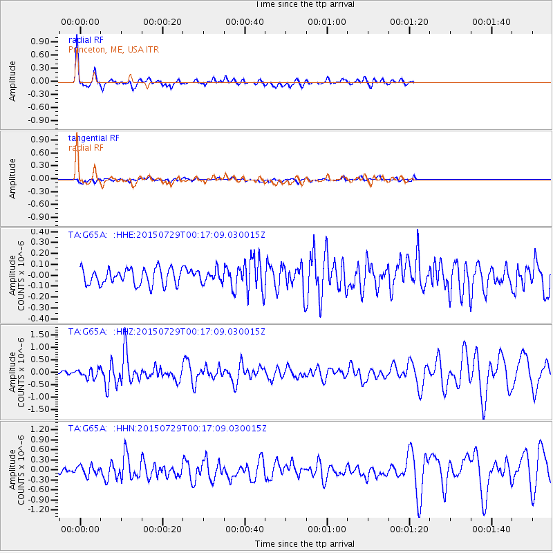
Signal To Noise
| Channel | StoN | STA | LTA |
| TA:G65A: :HHZ:20150729T00:17:09.030015Z | 2.4798832 | 1.7881348E-7 | 7.21056E-8 |
| TA:G65A: :HHN:20150729T00:17:09.030015Z | 1.6195989 | 1.4808242E-7 | 9.1431545E-8 |
| TA:G65A: :HHE:20150729T00:17:09.030015Z | 0.8804934 | 6.472323E-8 | 7.3507906E-8 |
| Arrivals |
| Ps | 4.1 SECOND |
| PpPs | 15 SECOND |
| PsPs/PpSs | 19 SECOND |


