You are here: Home > Network List > TA - USArray Transportable Network (new EarthScope stations) Stations List
> Station H58A Gabriels, NY, USA > Earthquake Result Viewer
H58A Gabriels, NY, USA - Earthquake Result Viewer
| Earthquake location: |
Panama-Colombia Border Region |
| Earthquake latitude/longitude: |
8.2/-77.3 |
| Earthquake time(UTC): |
2015/07/29 (210) 00:10:24 GMT |
| Earthquake Depth: |
10 km |
| Earthquake Magnitude: |
5.9 MWP, 6.1 MI |
| Earthquake Catalog/Contributor: |
NEIC PDE/NEIC COMCAT |
|
| Network: |
TA USArray Transportable Network (new EarthScope stations) |
| Station: |
H58A Gabriels, NY, USA |
| Lat/Lon: |
44.42 N/74.18 W |
| Elevation: |
537 m |
|
| Distance: |
36.1 deg |
| Az: |
3.79 deg |
| Baz: |
185.238 deg |
| Ray Param: |
0.07684036 |
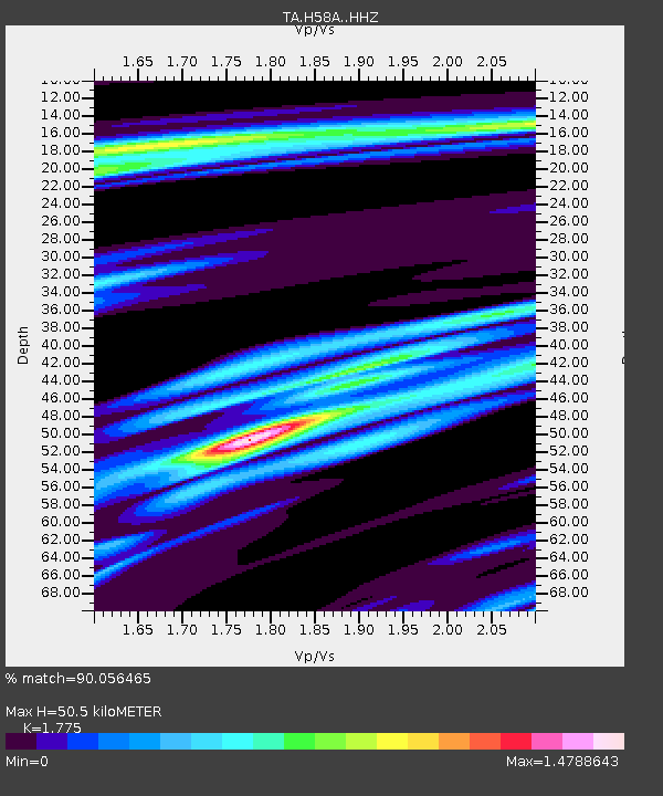
| Estimated Moho Depth: |
50.5 km |
| Estimated Crust Vp/Vs: |
1.77 |
| Assumed Crust Vp: |
6.419 km/s |
| Estimated Crust Vs: |
3.616 km/s |
| Estimated Crust Poisson's Ratio: |
0.27 |
|
| Radial Match: |
90.056465 % |
| Radial Bump: |
274 |
| Transverse Match: |
77.60354 % |
| Transverse Bump: |
400 |
| SOD ConfigId: |
7422571 |
| Insert Time: |
2019-04-20 01:36:39.102 +0000 |
| GWidth: |
2.5 |
| Max Bumps: |
400 |
| Tol: |
0.001 |
|

Signal To Noise
| Channel | StoN | STA | LTA |
| TA:H58A: :HHZ:20150729T00:16:55.15001Z | 3.9197085 | 1.6040872E-7 | 4.0923634E-8 |
| TA:H58A: :HHN:20150729T00:16:55.15001Z | 1.8354717 | 1.0173814E-7 | 5.542888E-8 |
| TA:H58A: :HHE:20150729T00:16:55.15001Z | 0.8756856 | 3.53891E-8 | 4.041302E-8 |
| Arrivals |
| Ps | 6.6 SECOND |
| PpPs | 20 SECOND |
| PsPs/PpSs | 27 SECOND |


