You are here: Home > Network List > TA - USArray Transportable Network (new EarthScope stations) Stations List
> Station H63A New Sharon, ME, USA > Earthquake Result Viewer
H63A New Sharon, ME, USA - Earthquake Result Viewer
| Earthquake location: |
Panama-Colombia Border Region |
| Earthquake latitude/longitude: |
8.2/-77.3 |
| Earthquake time(UTC): |
2015/07/29 (210) 00:10:24 GMT |
| Earthquake Depth: |
10 km |
| Earthquake Magnitude: |
5.9 MWP, 6.1 MI |
| Earthquake Catalog/Contributor: |
NEIC PDE/NEIC COMCAT |
|
| Network: |
TA USArray Transportable Network (new EarthScope stations) |
| Station: |
H63A New Sharon, ME, USA |
| Lat/Lon: |
44.66 N/70.04 W |
| Elevation: |
109 m |
|
| Distance: |
36.8 deg |
| Az: |
8.656 deg |
| Baz: |
192.049 deg |
| Ray Param: |
0.07646612 |
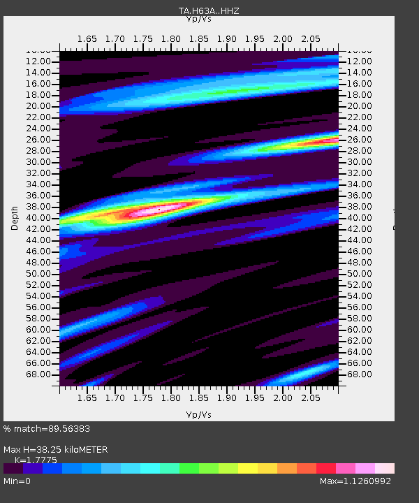
| Estimated Moho Depth: |
38.25 km |
| Estimated Crust Vp/Vs: |
1.78 |
| Assumed Crust Vp: |
6.419 km/s |
| Estimated Crust Vs: |
3.611 km/s |
| Estimated Crust Poisson's Ratio: |
0.27 |
|
| Radial Match: |
89.56383 % |
| Radial Bump: |
314 |
| Transverse Match: |
61.487823 % |
| Transverse Bump: |
400 |
| SOD ConfigId: |
7422571 |
| Insert Time: |
2019-04-20 01:36:42.015 +0000 |
| GWidth: |
2.5 |
| Max Bumps: |
400 |
| Tol: |
0.001 |
|
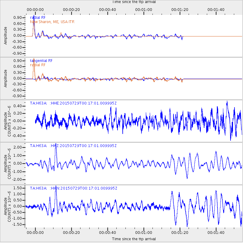
Signal To Noise
| Channel | StoN | STA | LTA |
| TA:H63A: :HHZ:20150729T00:17:01.009995Z | 2.7147677 | 2.3678514E-7 | 8.7221146E-8 |
| TA:H63A: :HHN:20150729T00:17:01.009995Z | 1.6697575 | 1.3135815E-7 | 7.8669E-8 |
| TA:H63A: :HHE:20150729T00:17:01.009995Z | 0.64649 | 6.543526E-8 | 1.012162E-7 |
| Arrivals |
| Ps | 5.0 SECOND |
| PpPs | 15 SECOND |
| PsPs/PpSs | 20 SECOND |


