You are here: Home > Network List > TA - USArray Transportable Network (new EarthScope stations) Stations List
> Station I57A Carthage, NY, USA > Earthquake Result Viewer
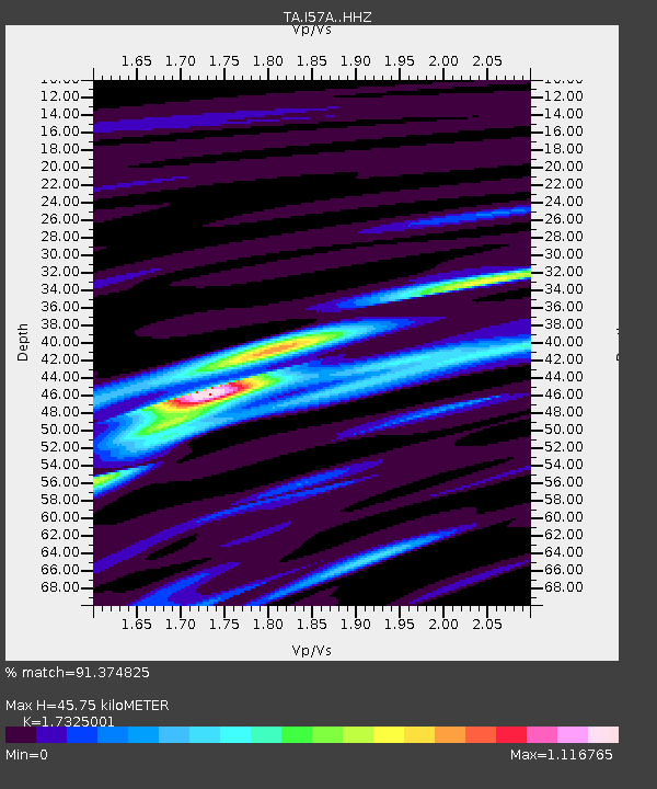
I57A Carthage, NY, USA - Earthquake Result Viewer
| Earthquake location: |
Panama-Colombia Border Region |
| Earthquake latitude/longitude: |
8.2/-77.3 |
| Earthquake time(UTC): |
2015/07/29 (210) 00:10:24 GMT |
| Earthquake Depth: |
10 km |
| Earthquake Magnitude: |
5.9 MWP, 6.1 MI |
| Earthquake Catalog/Contributor: |
NEIC PDE/NEIC COMCAT |
|
| Network: |
TA USArray Transportable Network (new EarthScope stations) |
| Station: |
I57A Carthage, NY, USA |
| Lat/Lon: |
43.94 N/75.66 W |
| Elevation: |
321 m |
|
| Distance: |
35.6 deg |
| Az: |
2.034 deg |
| Baz: |
182.787 deg |
| Ray Param: |
0.07714071 |
| Estimated Moho Depth: |
45.75 km |
| Estimated Crust Vp/Vs: |
1.73 |
| Assumed Crust Vp: |
6.419 km/s |
| Estimated Crust Vs: |
3.705 km/s |
| Estimated Crust Poisson's Ratio: |
0.25 |
|
| Radial Match: |
91.374825 % |
| Radial Bump: |
255 |
| Transverse Match: |
61.572155 % |
| Transverse Bump: |
400 |
| SOD ConfigId: |
7422571 |
| Insert Time: |
2019-04-20 01:36:48.079 +0000 |
| GWidth: |
2.5 |
| Max Bumps: |
400 |
| Tol: |
0.001 |
|

Signal To Noise
| Channel | StoN | STA | LTA |
| TA:I57A: :HHZ:20150729T00:16:50.409989Z | 3.1909273 | 1.7509157E-7 | 5.487169E-8 |
| TA:I57A: :HHN:20150729T00:16:50.409989Z | 2.0815206 | 1.2889802E-7 | 6.1924936E-8 |
| TA:I57A: :HHE:20150729T00:16:50.409989Z | 1.906297 | 6.585699E-8 | 3.4547075E-8 |
| Arrivals |
| Ps | 5.6 SECOND |
| PpPs | 18 SECOND |
| PsPs/PpSs | 24 SECOND |


