You are here: Home > Network List > TA - USArray Transportable Network (new EarthScope stations) Stations List
> Station K63A Dunstable, MA, USA > Earthquake Result Viewer
K63A Dunstable, MA, USA - Earthquake Result Viewer

| Earthquake location: |
Panama-Colombia Border Region |
| Earthquake latitude/longitude: |
8.2/-77.3 |
| Earthquake time(UTC): |
2015/07/29 (210) 00:10:24 GMT |
| Earthquake Depth: |
10 km |
| Earthquake Magnitude: |
5.9 MWP, 6.1 MI |
| Earthquake Catalog/Contributor: |
NEIC PDE/NEIC COMCAT |
|
| Network: |
TA USArray Transportable Network (new EarthScope stations) |
| Station: |
K63A Dunstable, MA, USA |
| Lat/Lon: |
42.69 N/71.53 W |
| Elevation: |
68 m |
|
| Distance: |
34.7 deg |
| Az: |
7.484 deg |
| Baz: |
190.07 deg |
| Ray Param: |
0.07761218 |
| Estimated Moho Depth: |
24.25 km |
| Estimated Crust Vp/Vs: |
1.79 |
| Assumed Crust Vp: |
6.419 km/s |
| Estimated Crust Vs: |
3.591 km/s |
| Estimated Crust Poisson's Ratio: |
0.27 |
|
| Radial Match: |
91.777435 % |
| Radial Bump: |
268 |
| Transverse Match: |
71.11124 % |
| Transverse Bump: |
400 |
| SOD ConfigId: |
7422571 |
| Insert Time: |
2019-04-20 01:37:06.146 +0000 |
| GWidth: |
2.5 |
| Max Bumps: |
400 |
| Tol: |
0.001 |
|
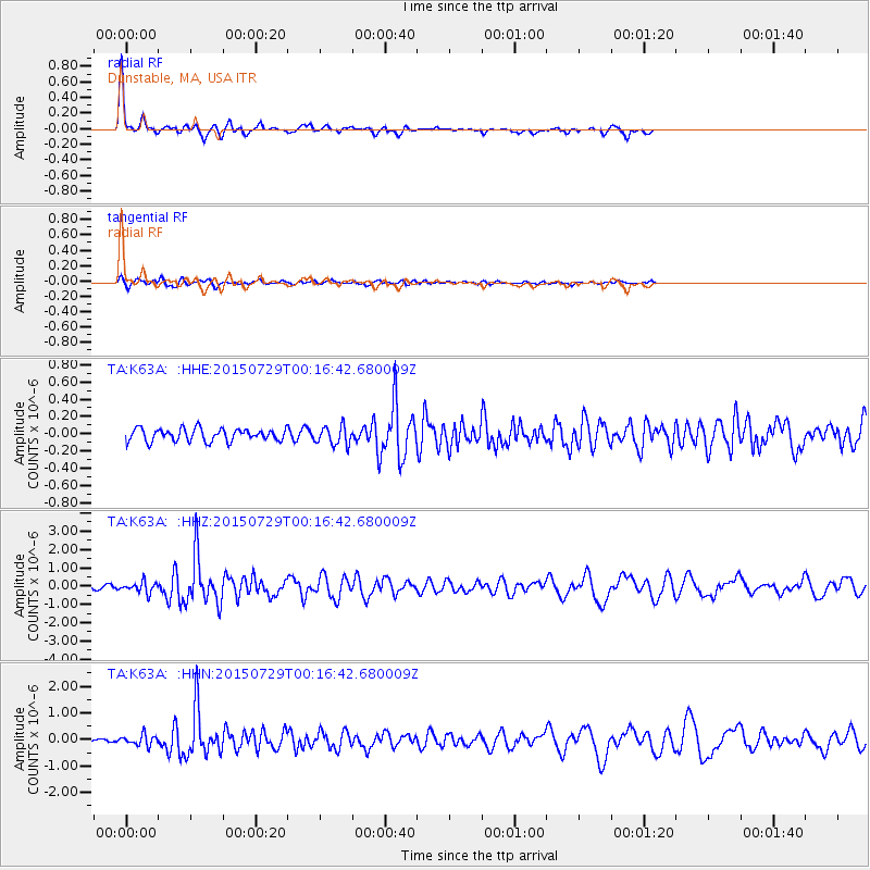
Signal To Noise
| Channel | StoN | STA | LTA |
| TA:K63A: :HHZ:20150729T00:16:42.680009Z | 3.6452312 | 2.8824286E-7 | 7.9073956E-8 |
| TA:K63A: :HHN:20150729T00:16:42.680009Z | 2.8568037 | 1.9766279E-7 | 6.919019E-8 |
| TA:K63A: :HHE:20150729T00:16:42.680009Z | 1.4935033 | 1.0523497E-7 | 7.046182E-8 |
| Arrivals |
| Ps | 3.2 SECOND |
| PpPs | 9.8 SECOND |
| PsPs/PpSs | 13 SECOND |


