You are here: Home > Network List > TA - USArray Transportable Network (new EarthScope stations) Stations List
> Station M26K Nabesna, AK, USA > Earthquake Result Viewer
M26K Nabesna, AK, USA - Earthquake Result Viewer
| Earthquake location: |
Panama-Colombia Border Region |
| Earthquake latitude/longitude: |
8.2/-77.3 |
| Earthquake time(UTC): |
2015/07/29 (210) 00:10:24 GMT |
| Earthquake Depth: |
10 km |
| Earthquake Magnitude: |
5.9 MWP, 6.1 MI |
| Earthquake Catalog/Contributor: |
NEIC PDE/NEIC COMCAT |
|
| Network: |
TA USArray Transportable Network (new EarthScope stations) |
| Station: |
M26K Nabesna, AK, USA |
| Lat/Lon: |
62.40 N/143.00 W |
| Elevation: |
888 m |
|
| Distance: |
71.6 deg |
| Az: |
333.428 deg |
| Baz: |
108.062 deg |
| Ray Param: |
0.05422073 |
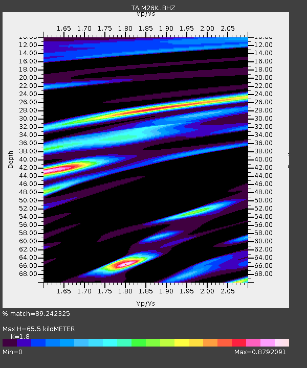
| Estimated Moho Depth: |
65.5 km |
| Estimated Crust Vp/Vs: |
1.80 |
| Assumed Crust Vp: |
6.566 km/s |
| Estimated Crust Vs: |
3.648 km/s |
| Estimated Crust Poisson's Ratio: |
0.28 |
|
| Radial Match: |
89.242325 % |
| Radial Bump: |
400 |
| Transverse Match: |
88.23947 % |
| Transverse Bump: |
400 |
| SOD ConfigId: |
7422571 |
| Insert Time: |
2019-04-20 01:37:14.634 +0000 |
| GWidth: |
2.5 |
| Max Bumps: |
400 |
| Tol: |
0.001 |
|

Signal To Noise
| Channel | StoN | STA | LTA |
| TA:M26K: :BHZ:20150729T00:21:13.40001Z | 13.25209 | 7.295793E-7 | 5.5053903E-8 |
| TA:M26K: :BHN:20150729T00:21:13.40001Z | 3.5236056 | 1.3347581E-7 | 3.788046E-8 |
| TA:M26K: :BHE:20150729T00:21:13.40001Z | 5.700311 | 1.8647083E-7 | 3.2712393E-8 |
| Arrivals |
| Ps | 8.3 SECOND |
| PpPs | 27 SECOND |
| PsPs/PpSs | 35 SECOND |


