You are here: Home > Network List > TA - USArray Transportable Network (new EarthScope stations) Stations List
> Station TPFO Pinon Flats, CA, USA > Earthquake Result Viewer
TPFO Pinon Flats, CA, USA - Earthquake Result Viewer
| Earthquake location: |
Panama-Colombia Border Region |
| Earthquake latitude/longitude: |
8.2/-77.3 |
| Earthquake time(UTC): |
2015/07/29 (210) 00:10:24 GMT |
| Earthquake Depth: |
10 km |
| Earthquake Magnitude: |
5.9 MWP, 6.1 MI |
| Earthquake Catalog/Contributor: |
NEIC PDE/NEIC COMCAT |
|
| Network: |
TA USArray Transportable Network (new EarthScope stations) |
| Station: |
TPFO Pinon Flats, CA, USA |
| Lat/Lon: |
33.61 N/116.45 W |
| Elevation: |
1275 m |
|
| Distance: |
44.0 deg |
| Az: |
310.695 deg |
| Baz: |
115.942 deg |
| Ray Param: |
0.07216745 |
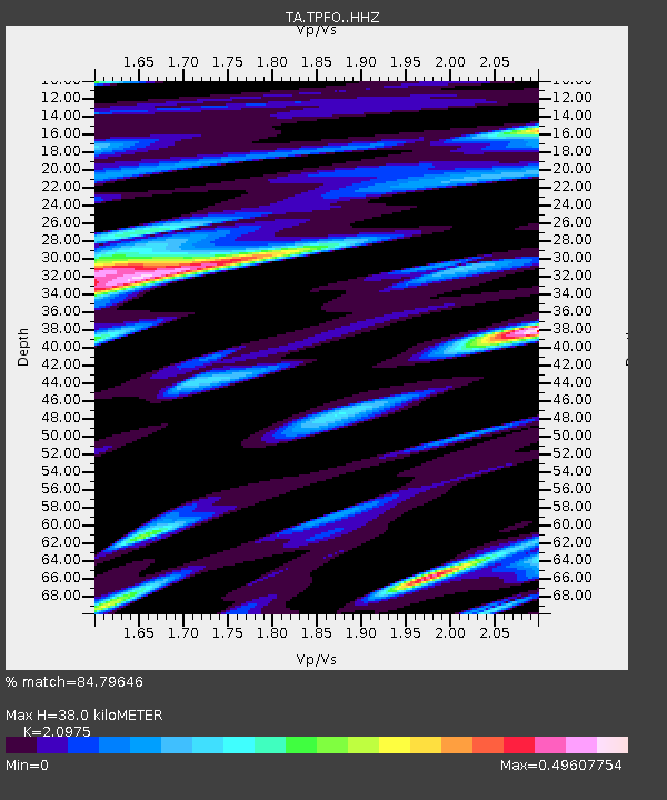
| Estimated Moho Depth: |
38.0 km |
| Estimated Crust Vp/Vs: |
2.10 |
| Assumed Crust Vp: |
6.264 km/s |
| Estimated Crust Vs: |
2.986 km/s |
| Estimated Crust Poisson's Ratio: |
0.35 |
|
| Radial Match: |
84.79646 % |
| Radial Bump: |
400 |
| Transverse Match: |
76.738396 % |
| Transverse Bump: |
384 |
| SOD ConfigId: |
7422571 |
| Insert Time: |
2019-04-20 01:37:41.980 +0000 |
| GWidth: |
2.5 |
| Max Bumps: |
400 |
| Tol: |
0.001 |
|
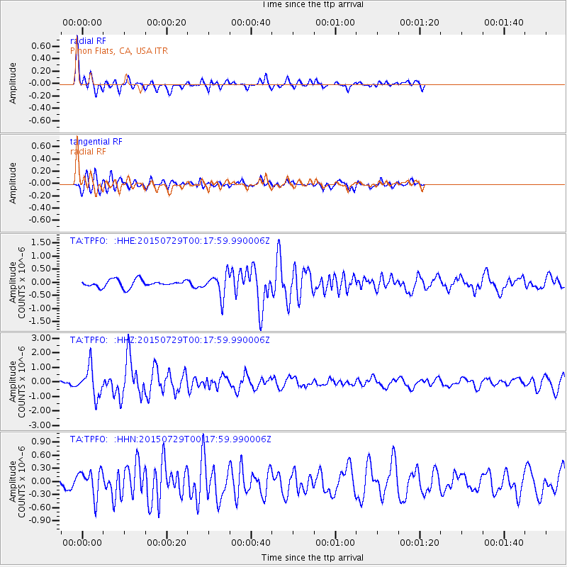
Signal To Noise
| Channel | StoN | STA | LTA |
| TA:TPFO: :HHZ:20150729T00:17:59.990006Z | 5.0742426 | 1.0138359E-6 | 1.9980043E-7 |
| TA:TPFO: :HHN:20150729T00:17:59.990006Z | 2.3038797 | 3.0887279E-7 | 1.3406637E-7 |
| TA:TPFO: :HHE:20150729T00:17:59.990006Z | 3.4424996 | 4.861275E-7 | 1.4121352E-7 |
| Arrivals |
| Ps | 7.0 SECOND |
| PpPs | 18 SECOND |
| PsPs/PpSs | 25 SECOND |


