You are here: Home > Network List > UW - Pacific Northwest Regional Seismic Network Stations List
> Station DAVN Chrisman Ranch, Davenport, WA, USA > Earthquake Result Viewer
DAVN Chrisman Ranch, Davenport, WA, USA - Earthquake Result Viewer

| Earthquake location: |
Panama-Colombia Border Region |
| Earthquake latitude/longitude: |
8.2/-77.3 |
| Earthquake time(UTC): |
2015/07/29 (210) 00:10:24 GMT |
| Earthquake Depth: |
10 km |
| Earthquake Magnitude: |
5.9 MWP, 6.1 MI |
| Earthquake Catalog/Contributor: |
NEIC PDE/NEIC COMCAT |
|
| Network: |
UW Pacific Northwest Regional Seismic Network |
| Station: |
DAVN Chrisman Ranch, Davenport, WA, USA |
| Lat/Lon: |
47.80 N/118.27 W |
| Elevation: |
495 m |
|
| Distance: |
52.5 deg |
| Az: |
326.128 deg |
| Baz: |
125.088 deg |
| Ray Param: |
0.06672798 |
| Estimated Moho Depth: |
31.5 km |
| Estimated Crust Vp/Vs: |
1.67 |
| Assumed Crust Vp: |
6.419 km/s |
| Estimated Crust Vs: |
3.844 km/s |
| Estimated Crust Poisson's Ratio: |
0.22 |
|
| Radial Match: |
93.743904 % |
| Radial Bump: |
373 |
| Transverse Match: |
79.94956 % |
| Transverse Bump: |
400 |
| SOD ConfigId: |
7422571 |
| Insert Time: |
2019-04-20 01:38:39.285 +0000 |
| GWidth: |
2.5 |
| Max Bumps: |
400 |
| Tol: |
0.001 |
|
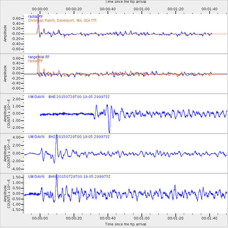
Signal To Noise
| Channel | StoN | STA | LTA |
| UW:DAVN: :BHZ:20150729T00:19:05.299973Z | 7.245688 | 7.6520246E-7 | 1.0560798E-7 |
| UW:DAVN: :BHN:20150729T00:19:05.299973Z | 4.2436085 | 2.7499829E-7 | 6.480294E-8 |
| UW:DAVN: :BHE:20150729T00:19:05.299973Z | 6.3161073 | 4.505952E-7 | 7.134065E-8 |
| Arrivals |
| Ps | 3.5 SECOND |
| PpPs | 12 SECOND |
| PsPs/PpSs | 16 SECOND |


