You are here: Home > Network List > 7A - Mid-Atlantic Geophysical Integrative Collaboration Stations List
> Station INTX Elkton, Virginia USA > Earthquake Result Viewer
INTX Elkton, Virginia USA - Earthquake Result Viewer
| Earthquake location: |
Southern Alaska |
| Earthquake latitude/longitude: |
59.9/-153.1 |
| Earthquake time(UTC): |
2015/07/29 (210) 02:35:58 GMT |
| Earthquake Depth: |
118 km |
| Earthquake Magnitude: |
6.3 ML, 6.2 MWP, 6.2 MI, 6.3 MWW |
| Earthquake Catalog/Contributor: |
NEIC PDE/NEIC COMCAT |
|
| Network: |
7A Mid-Atlantic Geophysical Integrative Collaboration |
| Station: |
INTX Elkton, Virginia USA |
| Lat/Lon: |
38.40 N/78.59 W |
| Elevation: |
320 m |
|
| Distance: |
50.2 deg |
| Az: |
80.23 deg |
| Baz: |
320.781 deg |
| Ray Param: |
0.067814425 |
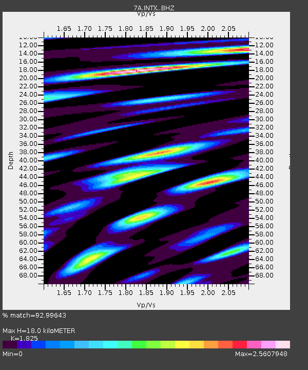
| Estimated Moho Depth: |
18.0 km |
| Estimated Crust Vp/Vs: |
1.83 |
| Assumed Crust Vp: |
6.159 km/s |
| Estimated Crust Vs: |
3.375 km/s |
| Estimated Crust Poisson's Ratio: |
0.29 |
|
| Radial Match: |
92.99643 % |
| Radial Bump: |
400 |
| Transverse Match: |
84.232834 % |
| Transverse Bump: |
400 |
| SOD ConfigId: |
7422571 |
| Insert Time: |
2019-04-20 01:41:23.546 +0000 |
| GWidth: |
2.5 |
| Max Bumps: |
400 |
| Tol: |
0.001 |
|

Signal To Noise
| Channel | StoN | STA | LTA |
| 7A:INTX: :BHZ:20150729T02:44:11.815002Z | 9.249123 | 9.368732E-7 | 1.012932E-7 |
| 7A:INTX: :BHN:20150729T02:44:11.815002Z | 5.22859 | 5.501985E-7 | 1.0522885E-7 |
| 7A:INTX: :BHE:20150729T02:44:11.815002Z | 3.2899911 | 4.498506E-7 | 1.3673308E-7 |
| Arrivals |
| Ps | 2.5 SECOND |
| PpPs | 7.8 SECOND |
| PsPs/PpSs | 10 SECOND |


