You are here: Home > Network List > 7A - Mid-Atlantic Geophysical Integrative Collaboration Stations List
> Station MOLE Hinton, Virginia USA > Earthquake Result Viewer
MOLE Hinton, Virginia USA - Earthquake Result Viewer
| Earthquake location: |
Southern Alaska |
| Earthquake latitude/longitude: |
59.9/-153.1 |
| Earthquake time(UTC): |
2015/07/29 (210) 02:35:58 GMT |
| Earthquake Depth: |
118 km |
| Earthquake Magnitude: |
6.3 ML, 6.2 MWP, 6.2 MI, 6.3 MWW |
| Earthquake Catalog/Contributor: |
NEIC PDE/NEIC COMCAT |
|
| Network: |
7A Mid-Atlantic Geophysical Integrative Collaboration |
| Station: |
MOLE Hinton, Virginia USA |
| Lat/Lon: |
38.49 N/79.02 W |
| Elevation: |
487 m |
|
| Distance: |
49.9 deg |
| Az: |
80.501 deg |
| Baz: |
320.688 deg |
| Ray Param: |
0.0680036 |
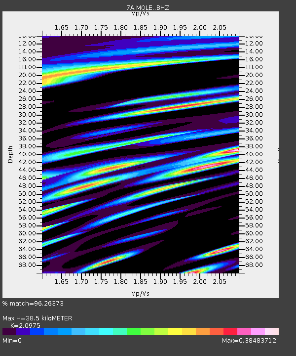
| Estimated Moho Depth: |
38.5 km |
| Estimated Crust Vp/Vs: |
2.10 |
| Assumed Crust Vp: |
6.159 km/s |
| Estimated Crust Vs: |
2.936 km/s |
| Estimated Crust Poisson's Ratio: |
0.35 |
|
| Radial Match: |
96.26373 % |
| Radial Bump: |
400 |
| Transverse Match: |
87.0186 % |
| Transverse Bump: |
400 |
| SOD ConfigId: |
7422571 |
| Insert Time: |
2019-04-20 01:41:28.503 +0000 |
| GWidth: |
2.5 |
| Max Bumps: |
400 |
| Tol: |
0.001 |
|

Signal To Noise
| Channel | StoN | STA | LTA |
| 7A:MOLE: :BHZ:20150729T02:44:09.709991Z | 5.6469727 | 9.1185024E-7 | 1.6147595E-7 |
| 7A:MOLE: :BHN:20150729T02:44:09.709991Z | 4.208351 | 3.206329E-7 | 7.618967E-8 |
| 7A:MOLE: :BHE:20150729T02:44:09.709991Z | 4.618037 | 2.5650718E-7 | 5.5544636E-8 |
| Arrivals |
| Ps | 7.2 SECOND |
| PpPs | 19 SECOND |
| PsPs/PpSs | 26 SECOND |


