You are here: Home > Network List > 7A - Mid-Atlantic Geophysical Integrative Collaboration Stations List
> Station YLDA Jackson, Virginia USA > Earthquake Result Viewer
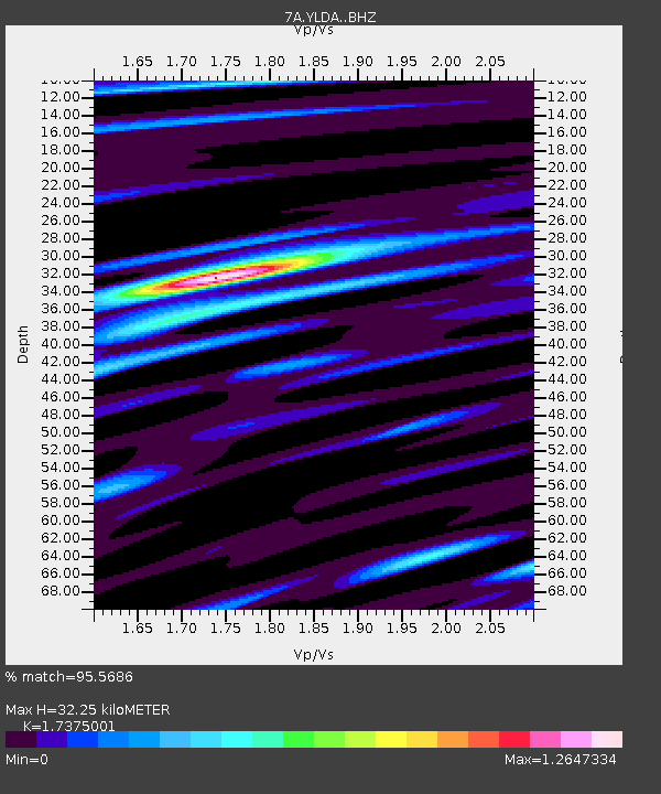
YLDA Jackson, Virginia USA - Earthquake Result Viewer
| Earthquake location: |
Southern Alaska |
| Earthquake latitude/longitude: |
59.9/-153.1 |
| Earthquake time(UTC): |
2015/07/29 (210) 02:35:58 GMT |
| Earthquake Depth: |
118 km |
| Earthquake Magnitude: |
6.3 ML, 6.2 MWP, 6.2 MI, 6.3 MWW |
| Earthquake Catalog/Contributor: |
NEIC PDE/NEIC COMCAT |
|
| Network: |
7A Mid-Atlantic Geophysical Integrative Collaboration |
| Station: |
YLDA Jackson, Virginia USA |
| Lat/Lon: |
37.86 N/77.84 W |
| Elevation: |
63 m |
|
| Distance: |
51.0 deg |
| Az: |
80.082 deg |
| Baz: |
321.143 deg |
| Ray Param: |
0.06732319 |
| Estimated Moho Depth: |
32.25 km |
| Estimated Crust Vp/Vs: |
1.74 |
| Assumed Crust Vp: |
6.565 km/s |
| Estimated Crust Vs: |
3.778 km/s |
| Estimated Crust Poisson's Ratio: |
0.25 |
|
| Radial Match: |
95.5686 % |
| Radial Bump: |
336 |
| Transverse Match: |
92.384476 % |
| Transverse Bump: |
400 |
| SOD ConfigId: |
7422571 |
| Insert Time: |
2019-04-20 01:41:36.116 +0000 |
| GWidth: |
2.5 |
| Max Bumps: |
400 |
| Tol: |
0.001 |
|

Signal To Noise
| Channel | StoN | STA | LTA |
| 7A:YLDA: :BHZ:20150729T02:44:17.714996Z | 9.955834 | 1.1618217E-6 | 1.1669757E-7 |
| 7A:YLDA: :BHN:20150729T02:44:17.714996Z | 6.185783 | 5.0700766E-7 | 8.196338E-8 |
| 7A:YLDA: :BHE:20150729T02:44:17.714996Z | 3.149639 | 2.3831012E-7 | 7.566268E-8 |
| Arrivals |
| Ps | 3.8 SECOND |
| PpPs | 13 SECOND |
| PsPs/PpSs | 17 SECOND |


