You are here: Home > Network List > AE - Arizona Broadband Seismic Network Stations List
> Station 113A Mohawk Valley, Roll, AZ, USA > Earthquake Result Viewer
113A Mohawk Valley, Roll, AZ, USA - Earthquake Result Viewer
| Earthquake location: |
Southern Alaska |
| Earthquake latitude/longitude: |
59.9/-153.1 |
| Earthquake time(UTC): |
2015/07/29 (210) 02:35:58 GMT |
| Earthquake Depth: |
118 km |
| Earthquake Magnitude: |
6.3 ML, 6.2 MWP, 6.2 MI, 6.3 MWW |
| Earthquake Catalog/Contributor: |
NEIC PDE/NEIC COMCAT |
|
| Network: |
AE Arizona Broadband Seismic Network |
| Station: |
113A Mohawk Valley, Roll, AZ, USA |
| Lat/Lon: |
32.77 N/113.77 W |
| Elevation: |
118 m |
|
| Distance: |
37.5 deg |
| Az: |
118.643 deg |
| Baz: |
328.326 deg |
| Ray Param: |
0.07571891 |
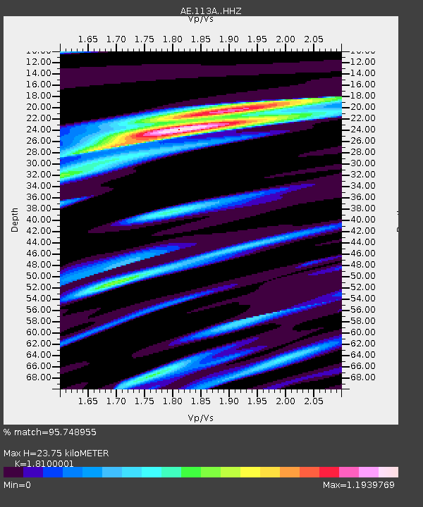
| Estimated Moho Depth: |
23.75 km |
| Estimated Crust Vp/Vs: |
1.81 |
| Assumed Crust Vp: |
6.264 km/s |
| Estimated Crust Vs: |
3.461 km/s |
| Estimated Crust Poisson's Ratio: |
0.28 |
|
| Radial Match: |
95.748955 % |
| Radial Bump: |
257 |
| Transverse Match: |
89.337296 % |
| Transverse Bump: |
400 |
| SOD ConfigId: |
7422571 |
| Insert Time: |
2019-04-20 01:41:41.749 +0000 |
| GWidth: |
2.5 |
| Max Bumps: |
400 |
| Tol: |
0.001 |
|

Signal To Noise
| Channel | StoN | STA | LTA |
| AE:113A: :HHZ:20150729T02:42:30.630005Z | 2.4853156 | 2.2850288E-7 | 9.1941196E-8 |
| AE:113A: :HHN:20150729T02:42:30.630005Z | 2.5223987 | 1.9191035E-7 | 7.608248E-8 |
| AE:113A: :HHE:20150729T02:42:30.630005Z | 1.1553358 | 1.3255766E-7 | 1.1473519E-7 |
| Arrivals |
| Ps | 3.3 SECOND |
| PpPs | 10.0 SECOND |
| PsPs/PpSs | 13 SECOND |


