You are here: Home > Network List > CN - Canadian National Seismograph Network Stations List
> Station ULM LAC DU BONNET, MB > Earthquake Result Viewer
ULM LAC DU BONNET, MB - Earthquake Result Viewer
| Earthquake location: |
Southern Alaska |
| Earthquake latitude/longitude: |
59.9/-153.1 |
| Earthquake time(UTC): |
2015/07/29 (210) 02:35:58 GMT |
| Earthquake Depth: |
118 km |
| Earthquake Magnitude: |
6.3 ML, 6.2 MWP, 6.2 MI, 6.3 MWW |
| Earthquake Catalog/Contributor: |
NEIC PDE/NEIC COMCAT |
|
| Network: |
CN Canadian National Seismograph Network |
| Station: |
ULM LAC DU BONNET, MB |
| Lat/Lon: |
50.25 N/95.88 W |
| Elevation: |
251 m |
|
| Distance: |
33.1 deg |
| Az: |
80.932 deg |
| Baz: |
309.159 deg |
| Ray Param: |
0.07800867 |
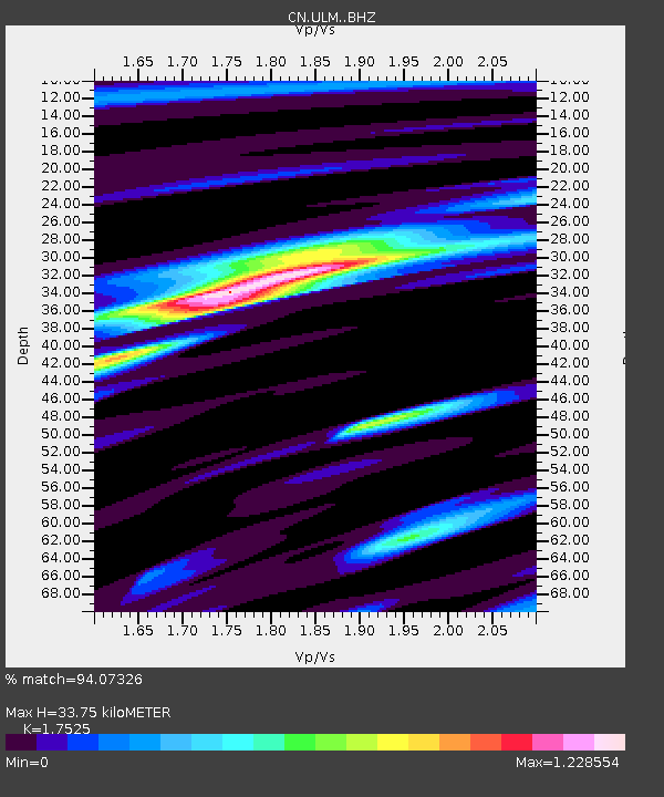
| Estimated Moho Depth: |
33.75 km |
| Estimated Crust Vp/Vs: |
1.75 |
| Assumed Crust Vp: |
6.459 km/s |
| Estimated Crust Vs: |
3.686 km/s |
| Estimated Crust Poisson's Ratio: |
0.26 |
|
| Radial Match: |
94.07326 % |
| Radial Bump: |
347 |
| Transverse Match: |
82.07523 % |
| Transverse Bump: |
400 |
| SOD ConfigId: |
7422571 |
| Insert Time: |
2019-04-20 01:43:12.154 +0000 |
| GWidth: |
2.5 |
| Max Bumps: |
400 |
| Tol: |
0.001 |
|

Signal To Noise
| Channel | StoN | STA | LTA |
| CN:ULM: :BHZ:20150729T02:41:53.399994Z | 33.997856 | 2.3132284E-6 | 6.804042E-8 |
| CN:ULM: :BHN:20150729T02:41:53.399994Z | 14.952756 | 9.613098E-7 | 6.428981E-8 |
| CN:ULM: :BHE:20150729T02:41:53.399994Z | 23.4121 | 1.1714833E-6 | 5.0037514E-8 |
| Arrivals |
| Ps | 4.3 SECOND |
| PpPs | 13 SECOND |
| PsPs/PpSs | 18 SECOND |


