You are here: Home > Network List > CU - Caribbean Network (USGS) Stations List
> Station MTDJ Mount Denham, Jamaica > Earthquake Result Viewer
MTDJ Mount Denham, Jamaica - Earthquake Result Viewer
| Earthquake location: |
Southern Alaska |
| Earthquake latitude/longitude: |
59.9/-153.1 |
| Earthquake time(UTC): |
2015/07/29 (210) 02:35:58 GMT |
| Earthquake Depth: |
118 km |
| Earthquake Magnitude: |
6.3 ML, 6.2 MWP, 6.2 MI, 6.3 MWW |
| Earthquake Catalog/Contributor: |
NEIC PDE/NEIC COMCAT |
|
| Network: |
CU Caribbean Network (USGS) |
| Station: |
MTDJ Mount Denham, Jamaica |
| Lat/Lon: |
18.23 N/77.53 W |
| Elevation: |
925 m |
|
| Distance: |
67.2 deg |
| Az: |
93.004 deg |
| Baz: |
328.02 deg |
| Ray Param: |
0.056824192 |
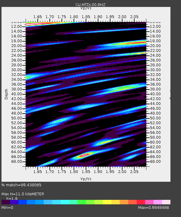
| Estimated Moho Depth: |
11.0 km |
| Estimated Crust Vp/Vs: |
1.60 |
| Assumed Crust Vp: |
4.662 km/s |
| Estimated Crust Vs: |
2.914 km/s |
| Estimated Crust Poisson's Ratio: |
0.18 |
|
| Radial Match: |
89.438065 % |
| Radial Bump: |
400 |
| Transverse Match: |
79.6783 % |
| Transverse Bump: |
400 |
| SOD ConfigId: |
7422571 |
| Insert Time: |
2019-04-20 01:43:15.618 +0000 |
| GWidth: |
2.5 |
| Max Bumps: |
400 |
| Tol: |
0.001 |
|

Signal To Noise
| Channel | StoN | STA | LTA |
| CU:MTDJ:00:BHZ:20150729T02:46:08.999023Z | 1.9764236 | 9.771632E-7 | 4.944098E-7 |
| CU:MTDJ:00:BH1:20150729T02:46:08.999023Z | 0.8133115 | 6.164861E-7 | 7.579951E-7 |
| CU:MTDJ:00:BH2:20150729T02:46:08.999023Z | 0.64135474 | 5.725654E-7 | 8.9274374E-7 |
| Arrivals |
| Ps | 1.4 SECOND |
| PpPs | 6.0 SECOND |
| PsPs/PpSs | 7.4 SECOND |


