You are here: Home > Network List > DK - Danish Seismological Network Stations List
> Station ANGG Tasiilaq, Greenland > Earthquake Result Viewer
ANGG Tasiilaq, Greenland - Earthquake Result Viewer
| Earthquake location: |
Southern Alaska |
| Earthquake latitude/longitude: |
59.9/-153.1 |
| Earthquake time(UTC): |
2015/07/29 (210) 02:35:58 GMT |
| Earthquake Depth: |
118 km |
| Earthquake Magnitude: |
6.3 ML, 6.2 MWP, 6.2 MI, 6.3 MWW |
| Earthquake Catalog/Contributor: |
NEIC PDE/NEIC COMCAT |
|
| Network: |
DK Danish Seismological Network |
| Station: |
ANGG Tasiilaq, Greenland |
| Lat/Lon: |
65.62 N/37.64 W |
| Elevation: |
9.0 m |
|
| Distance: |
45.9 deg |
| Az: |
31.468 deg |
| Baz: |
320.666 deg |
| Ray Param: |
0.07057639 |
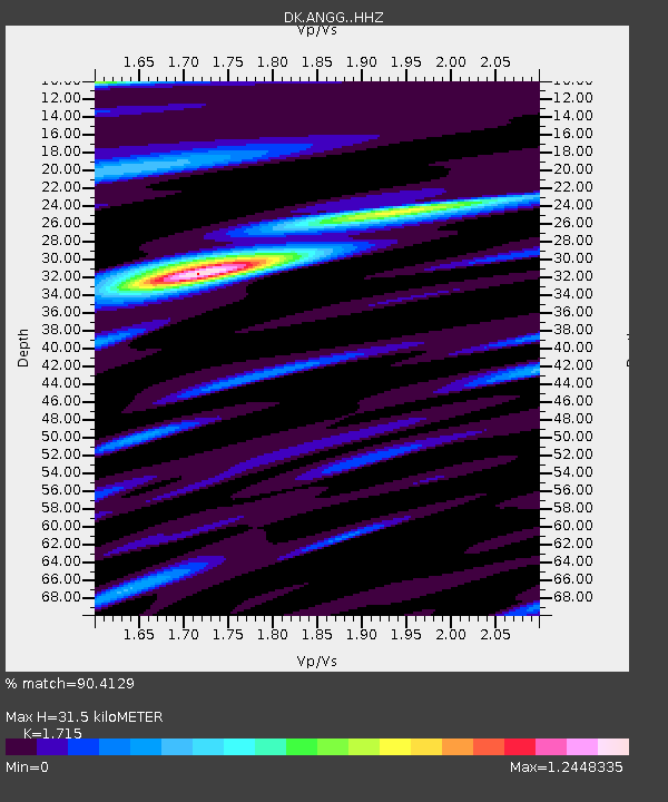
| Estimated Moho Depth: |
31.5 km |
| Estimated Crust Vp/Vs: |
1.72 |
| Assumed Crust Vp: |
6.24 km/s |
| Estimated Crust Vs: |
3.638 km/s |
| Estimated Crust Poisson's Ratio: |
0.24 |
|
| Radial Match: |
90.4129 % |
| Radial Bump: |
379 |
| Transverse Match: |
83.145096 % |
| Transverse Bump: |
400 |
| SOD ConfigId: |
7422571 |
| Insert Time: |
2019-04-20 01:43:21.893 +0000 |
| GWidth: |
2.5 |
| Max Bumps: |
400 |
| Tol: |
0.001 |
|

Signal To Noise
| Channel | StoN | STA | LTA |
| DK:ANGG: :HHZ:20150729T02:43:38.089996Z | 12.186545 | 1.5050588E-6 | 1.2350168E-7 |
| DK:ANGG: :HHN:20150729T02:43:38.089996Z | 7.433008 | 5.366923E-7 | 7.220392E-8 |
| DK:ANGG: :HHE:20150729T02:43:38.089996Z | 4.2023387 | 4.981626E-7 | 1.1854414E-7 |
| Arrivals |
| Ps | 3.8 SECOND |
| PpPs | 13 SECOND |
| PsPs/PpSs | 17 SECOND |


