You are here: Home > Network List > DK - Danish Seismological Network Stations List
> Station DBG Daneborg, Greenland > Earthquake Result Viewer
DBG Daneborg, Greenland - Earthquake Result Viewer

| Earthquake location: |
Southern Alaska |
| Earthquake latitude/longitude: |
59.9/-153.1 |
| Earthquake time(UTC): |
2015/07/29 (210) 02:35:58 GMT |
| Earthquake Depth: |
118 km |
| Earthquake Magnitude: |
6.3 ML, 6.2 MWP, 6.2 MI, 6.3 MWW |
| Earthquake Catalog/Contributor: |
NEIC PDE/NEIC COMCAT |
|
| Network: |
DK Danish Seismological Network |
| Station: |
DBG Daneborg, Greenland |
| Lat/Lon: |
74.31 N/20.22 W |
| Elevation: |
1.0 m |
|
| Distance: |
42.5 deg |
| Az: |
17.191 deg |
| Baz: |
326.811 deg |
| Ray Param: |
0.07274977 |
| Estimated Moho Depth: |
58.5 km |
| Estimated Crust Vp/Vs: |
1.82 |
| Assumed Crust Vp: |
6.459 km/s |
| Estimated Crust Vs: |
3.554 km/s |
| Estimated Crust Poisson's Ratio: |
0.28 |
|
| Radial Match: |
87.03606 % |
| Radial Bump: |
400 |
| Transverse Match: |
71.612335 % |
| Transverse Bump: |
400 |
| SOD ConfigId: |
7422571 |
| Insert Time: |
2019-04-20 01:43:23.362 +0000 |
| GWidth: |
2.5 |
| Max Bumps: |
400 |
| Tol: |
0.001 |
|
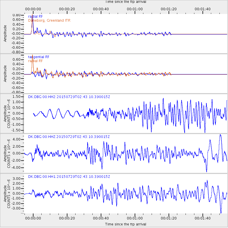
Signal To Noise
| Channel | StoN | STA | LTA |
| DK:DBG:00:HHZ:20150729T02:43:10.390015Z | 6.5062466 | 1.2053605E-6 | 1.8526204E-7 |
| DK:DBG:00:HH1:20150729T02:43:10.390015Z | 5.02822 | 3.8297404E-7 | 7.616493E-8 |
| DK:DBG:00:HH2:20150729T02:43:10.390015Z | 0.9547497 | 2.2083265E-7 | 2.31299E-7 |
| Arrivals |
| Ps | 7.9 SECOND |
| PpPs | 24 SECOND |
| PsPs/PpSs | 32 SECOND |


