You are here: Home > Network List > KN - Kyrgyz Seismic Telemetry Network Stations List
> Station AML - > Earthquake Result Viewer
AML - - Earthquake Result Viewer
| Earthquake location: |
Southern Alaska |
| Earthquake latitude/longitude: |
59.9/-153.1 |
| Earthquake time(UTC): |
2015/07/29 (210) 02:35:58 GMT |
| Earthquake Depth: |
118 km |
| Earthquake Magnitude: |
6.3 ML, 6.2 MWP, 6.2 MI, 6.3 MWW |
| Earthquake Catalog/Contributor: |
NEIC PDE/NEIC COMCAT |
|
| Network: |
KN Kyrgyz Seismic Telemetry Network |
| Station: |
AML - |
| Lat/Lon: |
42.13 N/73.69 E |
| Elevation: |
3400 m |
|
| Distance: |
71.3 deg |
| Az: |
325.103 deg |
| Baz: |
22.811 deg |
| Ray Param: |
0.05410927 |
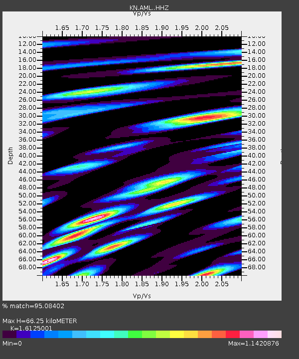
| Estimated Moho Depth: |
66.25 km |
| Estimated Crust Vp/Vs: |
1.61 |
| Assumed Crust Vp: |
6.316 km/s |
| Estimated Crust Vs: |
3.917 km/s |
| Estimated Crust Poisson's Ratio: |
0.19 |
|
| Radial Match: |
95.08402 % |
| Radial Bump: |
400 |
| Transverse Match: |
86.1552 % |
| Transverse Bump: |
400 |
| SOD ConfigId: |
7422571 |
| Insert Time: |
2019-04-20 01:45:03.751 +0000 |
| GWidth: |
2.5 |
| Max Bumps: |
400 |
| Tol: |
0.001 |
|

Signal To Noise
| Channel | StoN | STA | LTA |
| KN:AML: :HHZ:20150729T02:46:32.880005Z | 67.855606 | 1.98741E-6 | 2.9288813E-8 |
| KN:AML: :HHN:20150729T02:46:32.880005Z | 22.674374 | 6.931821E-7 | 3.0571165E-8 |
| KN:AML: :HHE:20150729T02:46:32.880005Z | 19.132576 | 4.490853E-7 | 2.3472285E-8 |
| Arrivals |
| Ps | 6.7 SECOND |
| PpPs | 26 SECOND |
| PsPs/PpSs | 33 SECOND |


