You are here: Home > Network List > LD - Lamont-Doherty Cooperative Seismographic Network Stations List
> Station FRNY Flat Rock, Altona, NY > Earthquake Result Viewer
FRNY Flat Rock, Altona, NY - Earthquake Result Viewer
| Earthquake location: |
Southern Alaska |
| Earthquake latitude/longitude: |
59.9/-153.1 |
| Earthquake time(UTC): |
2015/07/29 (210) 02:35:58 GMT |
| Earthquake Depth: |
118 km |
| Earthquake Magnitude: |
6.3 ML, 6.2 MWP, 6.2 MI, 6.3 MWW |
| Earthquake Catalog/Contributor: |
NEIC PDE/NEIC COMCAT |
|
| Network: |
LD Lamont-Doherty Cooperative Seismographic Network |
| Station: |
FRNY Flat Rock, Altona, NY |
| Lat/Lon: |
44.83 N/73.59 W |
| Elevation: |
242 m |
|
| Distance: |
47.8 deg |
| Az: |
70.914 deg |
| Baz: |
317.97 deg |
| Ray Param: |
0.069400705 |
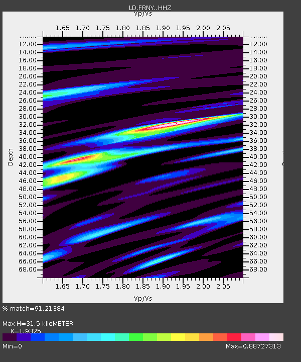
| Estimated Moho Depth: |
31.5 km |
| Estimated Crust Vp/Vs: |
1.93 |
| Assumed Crust Vp: |
6.419 km/s |
| Estimated Crust Vs: |
3.322 km/s |
| Estimated Crust Poisson's Ratio: |
0.32 |
|
| Radial Match: |
91.21384 % |
| Radial Bump: |
315 |
| Transverse Match: |
82.59405 % |
| Transverse Bump: |
400 |
| SOD ConfigId: |
7422571 |
| Insert Time: |
2019-04-20 01:45:39.844 +0000 |
| GWidth: |
2.5 |
| Max Bumps: |
400 |
| Tol: |
0.001 |
|

Signal To Noise
| Channel | StoN | STA | LTA |
| LD:FRNY: :HHZ:20150729T02:43:53.138Z | 12.785701 | 1.0415589E-6 | 8.1462794E-8 |
| LD:FRNY: :HHN:20150729T02:43:53.138Z | 10.84095 | 4.8198234E-7 | 4.445942E-8 |
| LD:FRNY: :HHE:20150729T02:43:53.138Z | 6.461475 | 4.112404E-7 | 6.3644976E-8 |
| Arrivals |
| Ps | 4.8 SECOND |
| PpPs | 14 SECOND |
| PsPs/PpSs | 18 SECOND |


